کافی نت ایفل
Users' Diaries
Recent diary entries
Having both GoPro Hero11 and Max360, I was curious whether there would be any use from running both cameras at the same time. While Max 360 captures all around, would Hero 11 possibly have better resolution, which could be useful for streetview platforms like Mapillary and Panoramax, thus also providing additional detail for OSM mapping?
Here’s the same object - a surveillance camera - from both action cameras. Hero11 is even a little bit further away.
Max360:
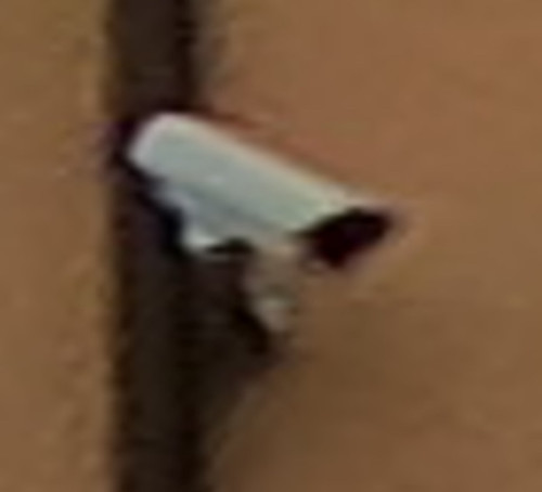
Hero11:

As can be seen, Hero11 does offer notably better resolution, which could be crucial with signs and other objects - thus it does make sense to collect imagery with two cameras like that at the same time.
My first diary entry in thirteen years, and so much has changed on OSM. The editing tools have come on so much, and there is now an incredible level of detail, even in the rural town I’m living in now. I think I need to go back to the documentation to refresh my memory and look at adding all the things missing in my neighbourhood.
Why is there no Arabic language on maps?لماذا لاتوجد اللغة العربية في الخرائط
It is for doing mapping so I can get better, so thank you guys! Google Maps is my main option but I am in Rank 149 of OpenStreetMap! Thank you for @DavidDean as he said he was in the top 50 in 2008! I specifically like you guys! Kind Regards, Brilloant
2024年4月3號花蓮外海發生規範 7.2 強烈地動,造成嚴重 ê 道路中斷 kah 人命傷亡。OpenStreetMap Taiwan 社群開設下跤三个專案,向望各界鍵盤圖客支援繪製花蓮 ê 建築、土地利用 kah 落勾 ê 道路 kah 溪流:
- 中橫公路東段:https://tasks.hotosm.org/projects/16508
- 蘇花公路:https://tasks.hotosm.org/projects/16507/
- 花東縱谷北段新城、秀林、花蓮、吉安、壽豐:https://tasks.hotosm.org/projects/16505
這馬佇咧參詳地動了後 ê 衛星影像捐贈 ē-tàng iōng tī 繪製新 ê 地貌,並且 tī 主要災後復原了後,期待直接 tī 在庄 ê 實體活動,幫助在庄 ê 人。
On April 3, 2024, an earthquake happened outside the coast of Hualien, which caused serious roadblocks and human casualties. OpenStreetMap Taiwan has opened 3 projects for mapping affected areas, requesting worldwide mappers to map buildings, landuses, missing roads or waterways in Hualien.
- Central Cross-island Highway eastern section: https://tasks.hotosm.org/projects/16508
- Suhua Highway: https://tasks.hotosm.org/projects/16507/
- Hua-Dong Valley northern part, Sincheng, Siulin, Hualien, Ji’an, Shoufong: https://tasks.hotosm.org/projects/16505
We are talking if there is a possibility to donate the newest satellite image after the earthquake to map the after-earthquake situations. And the possibility of hosting mapping events on-site after the affected area returns to normal, helping locals by mapping the newest map data.
Zawsze można spotkać się
2024年4月3日花蓮外海發生規範7.2強烈地震,造成嚴重的道路中斷與人命傷亡。OpenStreetMap Taiwan 社群開設以下三個專案,企盼各地鍵盤圖客支援繪製花蓮的建築、土地利用與遺漏的道路與溪流:
- 中橫公路東段:https://tasks.hotosm.org/projects/16508
- 蘇花公路:https://tasks.hotosm.org/projects/16507/
- 花東縱谷北段新城、秀林、花蓮、吉安、壽豐:https://tasks.hotosm.org/projects/16505
目前在洽談震災後的衛星影像捐贈用來繪製新的地貌,並且在主要災後之後,期待直接在當地的實體活動,幫助在地民眾。

That’s the name of the workshops I facilitated last week, with the goal of introducing/promoting OpenStreetMap, along with introducing tools like FieldPaper, OpenAerialMap, Sketch-Map Tool and Umap, to meet the objectives of local DRR practitioners’ upcoming mapping initiative.
Last Friday I had conducted two workshop in Iloilo, one (unplanned) for Iloilo’s Provincial DRRMO (disaster agency), and another for Iloilo City own DRRMO. In the Philippines, city charters may provide them autonomy from the geographic province they’re part of. These Disaster Risk Reduction Management Offices (a tongue-full, I know) are the government agencies responsible for mitigating localized disaster risks, and planning for disaster prevention for their respective territories.
Last year, in a random visit in Iloilo, I met some folks from the City DRRMO team and since then, I found out that they’ve capturing community-based hazard risks and perceptions using FieldPapers. Unfortunately, FieldPapers uptime wasn’t as reliable as before, and eventually the built-in Bing imagery became unavailable, too.
I’ve kept in touch with the City’s DRRMO team, and when I told them of a planned (gustatory) visit, they asked if I could run another training workshop for them. The small workshop was planned for a dozen people, but the day before the workshop I was surprised to learn than they confirmed 28 participants, and couldn’t even accommodate my own guests.
Well, that’s how I ended up with two separate workshops, discussing the same topic, but interestingly, the engagement was different with one group being more technical, and familiar with geodata/GIS/maps, and the other are more focused on being able to collect local spatial knowledge.
Anyway, with the feedback about issues they’ve been encountering with FieldPapers, I ran into the updated Sketch-Map Tool which now has built-in ESRI Aerial Imagery included.
FieldPapers (FP)
One of the earliest Pen & Paper tools I’ve learned to like, especially when working with folks averse to “tech”. It’s cheap, and it (used to be quite) reliable.
Creating maps could be tedious, manually requiring people to manually define their area of interest. I think it’s been years since the search function last worked properly.
The participant’s favorite feature is FP’s ability to use external TMS endpoints, and in our case, I demonstrated how OpenAerialMap imagery taken from drones can be used to deploy fresh maps that can be used as background of maps they wish to deploy on the ground.
They participants also like how FP serves TMS tiles of the uploaded snapshot (marked-up) map, which they can use as a background layer on iD (or another editor) for digitizing on OpenStreetMap.
Maximum paper size is ISO A3, which isn’t probably big enough when you expect participants to work together as large groups. That size is more than sufficient for individual mappers though.
If the users aren’t conscious about it, they may inadvertently create atlases with snapshots that may reveal personal or private information, so that’s one thing users should really watch out for.
Sketch-Map Tool (SMT)
This recently revamped tool now comes with built-in satellite imagery from ESRI, but you’re limited to that or the Mapnik (OpenStreetMap’s default layer) background for your maps.
The interface for creating maps is more friendly, and the OHSOME map quality report helpful, but it becomes tedious when you need to create separate maps for a large area, which one has to to create one-by-one.
One of the favorite features for SMT is it’s built-in ability to digitize (properly) marked features and create GeoTIFF and GeoJSON files out of the marked-up map. The data is not stored in HEIGIT's servers, so the risk of accidental disclosure of private information is minimized. Update: 2024-04-22 According to mschaub’s comment, the data is actually stored in HeiGIT’s server, but becomes inaccessible after a day:
One small correction I would like to make (or maybe I misunderstood you): We do store the original sketch map and the uploaded sketch map with markings on them on our servers. The first one, we need to be able to do georeferencing of the sketch map after it was uploaded. The second one we store to be able to improve our machine learning models which are responsible for detecting the markings. We do point this out to the users (see text on the upload dialog). But it is not possible, even with the right URL, to download any of those files one day after they were created. So data is stored on our server, but the risk of accidental disclosure of private information is also minimized.
During the role-playing segment, we experienced how quick the process may be like, from map creation, to the mark-up/reporting process, and the automatic digitization, then visualizing the created GeoJSON files quickly, using Umap.
Over-all, everyone found the tools easy-enough to learn, and accessible for their capacity level.
At it is, these two tools are complementary and one could be more useful than the other, depending on the users’ priorities. To wit:
| FieldPapers | Sketch-Map Tool | |
|---|---|---|
| supported layer | Mapnik, HOTOSM, TMS | Mapnik, ESRI Imagery |
| interface | functional, but search doesn’t work | more user-friendly, works as expected |
| registration | optional | none |
| max. paper size | ISO A3 | ISO A1 |
| geodata | GeoTIFF | GeoTIFF, GeoJSON |
| TMS of marked-up map | yes | no |
| multi-map support | yes | tedious |
| privacy risks | moderate | low |
I’m excited by the initiatives being drawn-up by both DRRMOs, though they are still working independent of each other.
The search and rescue team, and the local fire department, were very enthusiastic about using Pen & Paper to help map location of water wells (parts of the city are experiencing drought), while the search and rescue intends to use them for mapping highways attributes (width and access) and missing footways and paths, to improve response times during emergencies.
I see a potential to make more use of OpenStreetMap data in their local communities, encouraging local contributors to keep the map updated and relevant for their own needs, and the participatory approach they are undertaking, in collecting local spatial knowledge and experience, which could lead to improved usability of gained results for local capacity assessments, and the role of the OSM ecosystem of data and tools serving as a bridge into their formal DRR process.
I would’ve loved to see more of the local active mappers participating in the event and planned activities, but unfortunately, we failed to receive any word from the folks we reached out to.
Gallery
Below is a collage of some photos from the activity.
While commercial map providers like Google, provide map data in local Indian languages, the local language labels are usually transliterated from English, resulting in errors. OSM, Wikidata and Wikipedia platforms provide a way to improve the local language maps leveraging multilingual labels through Wikidata identifiers on OSM, through semi automated updates. For good quality maps on Wikipedia and OSM, the Wikidata location needs to be accurate and Wikidata identifier should be uniquely mapped to the actual OSM geometry. I worked on removing the mismatches for villages of a district in Andhra Pradesh. I have documented my experience as clearly as possible, so that even users with less programming and tools skills can contribute to the work. As an example, identifying and fixing errors in Wikidata location is given below.
Identifying and fixing error in locations on Wikidata pages
 The geodata is presented in Wikidata page and corresponding English Wikipedia article page using OSM as background map. If one notices that the marker is not near to the names identified on OSM map, then there is possibility of an error. Even if the name is identified on OSM background map, selecting different zoom levels allows checking whether the place is in the correct location.
 The correct geolocation is obtained from Open Data compliant StateGIS portal run by Bharatmaps.
 After Wikidata coordinate location is updated with the correct data, Wikidata page and the corresponding English wiki article show the correct map.
Full article covers how to identify more complex errors based on the geographical distance between Wikidata location and OSM node location and also when the Wikidata and OSM geometry that is associated are outside the area of interest. Sample Wikidata Sparql scripts leveraging Sophox interface to OSM, which can be easily edited are provided to help contributors with less programming and tool skills to contribute to these efforts.
For more information, check out Improving geodata accuracy on OSM and Wikidata (Full article on OSM wiki) and let me know your feedback.

![]() As we announced in a previous post, we continue to inform the OpenStreetMap LATAM community about the SOTM LATAM 2024 committees, and now we present the Programming Committee.
As we announced in a previous post, we continue to inform the OpenStreetMap LATAM community about the SOTM LATAM 2024 committees, and now we present the Programming Committee.
The main functions of this committee are:
- Propose the activity program during the days of the SOTM
- Design protocol activities
- Design the event Tracks
- Design parallel activities
- Design recreation activities
- Coordinate with the speakers what is necessary for their participations
- Evaluate the carrying out of recognition of mappers in the region
The committee members are:
| Member | Representation | Position | Role |
|---|---|---|---|
| Anderson Toniazo | OSM Brasil | Member | Organizing Committee |
| Virginia Brussa | OSM Argentina | Member | |
| Olga Paredes | OSM Bolivia | Member | |
| Yasmila Herrera | Yeka Street | Member | |
| Sebastián Bravo | Youthmappers SAGEMA | Member | |
| Mariela Centeno | Youthmappers ESPE | Member | |
| Juan A. Barajas | Youthmappers LATAM | Member | Organizing Committee |
This committee should have its first meeting in the coming days to elect its president and begin carrying out its duties.
Posted by Cyberjuan on 9 April 2024 in Spanish (Español).
Last updated on 10 April 2024.
![]() Tal como anunciamos en anterior post, seguimos informando a la comunidad OpenStreetMap LATAM sobre los comités del SOTM LATAM 2024, ahora les presentamos al Comité de Programación.
Tal como anunciamos en anterior post, seguimos informando a la comunidad OpenStreetMap LATAM sobre los comités del SOTM LATAM 2024, ahora les presentamos al Comité de Programación.
Este comité tiene como principales funciones:
- Proponer la programación de actividades durante los días del SOTM
- Diseñar las Actividades protocolares
- Diseñar los Tracks del evento
- Diseñar las Actividades paralelas
- Diseñar las Actividades de recreación
- Coordinar con los ponentes lo necesario para sus participaciones
- Evaluar la realización de reconocimientos a los mapeadores de la región
Los miembros del comité son:
| Miembro | Representación | Cargo | Rol |
|---|---|---|---|
| Anderson Toniazo | OSM Brasil | Miembro | Comité de Organización |
| Virginia Brussa | OSM Argentina | Miembro | |
| Olga Paredes | OSM Bolivia | Miembro | |
| Yasmila Herrera | Yeka Street | Miembro | |
| Sebastián Bravo | Youthmappers SAGEMA | Miembro | |
| Mariela Centeno | Youthmappers ESPE | Miembro | |
| Juan A. Barajas | Youthmappers LATAM | Miembro | Comité de Organización |
Este comité debe tener su primera reunión en los próximos días para elegir a su presidente y empezar a cumplir sus funciones.
Si usted cree que puede aportar a este comité favor de comunicarse al correo state arroba osmlatam punto org.
Well did that alone
![]() As we announced in the previous post, we continue to inform the OpenStreetMap LATAM community about the SOTM LATAM 2024 committees, and now we present the Academic Program Committee.
As we announced in the previous post, we continue to inform the OpenStreetMap LATAM community about the SOTM LATAM 2024 committees, and now we present the Academic Program Committee.
The main functions of this committee are:
- Evaluate the presentation proposals received
- Evaluate scholarship applications received
- Management of travel and accommodation scholarships
As additional information for those interested in presenting a talk or presentation, the topics may be (but are not limited to):
- Mapping projects developed or under development in the region.
- Projects to improve the labeling system in the region.
- Projects to improve the use of notes in the region.
- Extrinsic or intrinsic quality assessment of OpenStreetMap data
- Analysis of contribution patterns in OpenStreetMap
- Generation of new and scientifically valuable datasets from OpenStreetMap
- Assessments of data import procedures and their impacts on data and community
- Integration between OpenStreetMap and other data sources (authoritative, user-generated, or otherwise valuable to OpenStreetMap)
- Analysis/comparison of available software for scientific purposes related to OpenStreetMap
- Novel approaches to facilitate or improve data collection and/or data quality in OpenStreetMap (e.g. through gamification or citizen science approaches)
- Artificial Intelligence / Machine Learning from, and with OpenStreetMap (e.g. AI-assisted mapping)
- Open research problems in OpenStreetMap and challenges for the scientific community
- Cultural, political, and organizational aspects of data production and usage practices in OpenStreetMap
- Studies using OpenStreetMap data in scientific domains
- Reviews of any scientific aspect connected to OpenStreetMap
The committee members are:
| Member | Representation | Position | Role |
|---|---|---|---|
| Rodrigo Smarzaro | UMBRAOSM | Member | Organizing committee |
| Matheus Correia | COIMBRA Univ. | Member | |
| Nathan Damas | Youthmappers UFPR | Member | |
| Kauê de Moraes V. | Youthmappers UFPR | Member | |
| Maya Lovo | Youthmappers | Member | |
| Carolina Garcia | Youthmappers ESPE | Member | |
| Patricia Llanos | SBCS | Member | |
| Sandra Hernandez | Youthmappers Uaemex | Member |
This committee should have its first meeting in the coming days to elect its president and begin carrying out its duties.
Posted by Cyberjuan on 9 April 2024 in Spanish (Español).
Last updated on 10 April 2024.
![]() Tal como anunciamos en el anterior post, seguimos informando a la comunidad OpenStreetMap LATAM sobre los comités del SOTM LATAM 2024, ahora les presentamos al Comité de Programa Académico.
Tal como anunciamos en el anterior post, seguimos informando a la comunidad OpenStreetMap LATAM sobre los comités del SOTM LATAM 2024, ahora les presentamos al Comité de Programa Académico.
Este comité tiene como principales funciones:
- Evaluar las propuestas de ponencias recibidas
- Evaluar las solicitudes de becas recibidas
- Gestión de becas de viajes y alojamiento.
Como información adicional para quienes estén interesados en presentar una charla o ponencia, los temas de estas pueden ser (pero no están limitadas a):
- Proyectos de mapeo desarrollados o en desarrollo en la región.
- Proyectos para mejorar el sistema de etiquetado en la región.
- Proyectos para mejorar el uso de las notas en la región.
- Evaluación de la calidad de los datos de OpenStreetMap
- Análisis de patrones de contribución en OpenStreetMap
- Generación de conjuntos de datos nuevos y científicamente valiosos a partir de OpenStreetMap
- Evaluaciones de los procedimientos de importación de datos y sus impactos en los datos y la comunidad.
- Integración entre OpenStreetMap y otras fuentes de datos (autorizadas, generadas por el usuario o de otro modo valiosas para OpenStreetMap)
- Análisis/comparación de software disponible con fines científicos relacionados con OpenStreetMap
- Enfoques novedosos para facilitar o mejorar la recopilación de datos y/o la calidad de los datos en OpenStreetMap (por ejemplo, a través de enfoques de gamificación o ciencia ciudadana)
- Inteligencia artificial/aprendizaje automático a partir de y con OpenStreetMap (por ejemplo, mapeo asistido por IA)
- Problemas abiertos de investigación en OpenStreetMap y desafíos para la comunidad científica
- Aspectos culturales, políticos y organizativos de las prácticas de producción y uso de datos en OpenStreetMap
- Estudios que utilizan datos de OpenStreetMap en dominios científicos
- Reseñas de cualquier aspecto científico relacionado con OpenStreetMap.
Los miembros del comité son:
| Miembro | Representación | Cargo | Rol |
|---|---|---|---|
| Rodrigo Smarzaro | UMBRAOSM | Miembro | Organizing committee |
| Matheus Correia | Univ. COIMBRA | Miembro | |
| Nathan Damas | Youthmappers UFPR | Miembro | |
| Kauê de Moraes V. | Youthmappers UFPR | Miembro | |
| Maya Lovo | Youthmappers | Miembro | |
| Carolina Garcia | Youthmappers ESPE | Miembro | |
| Patricia Llanos | SBCS | Miembro | |
| Sandra Hernandez | Youthmappers Uaemex | Miembro |
Este comité debe tener su primera reunión en los próximos días para elegir a su presidente y empezar a cumplir sus funciones.
Si usted cree que puede aportar a este comité favor de comunicarse al correo state arroba osmlatam punto org.

So I thought surveys meant that I go out and ask people… conduct a survey, but apparently it means that you have been there personally to check it… so… that means I didn’t tag any of my entries where it would apply with this… lol

Welcome to my fourth OpenStreetMap NextGen development diary.
Sorry for being a day late! I wanted to finish up one of the new features which caused this small delay. ✨
🔖 You can read my other development diaries here:
https://www.openstreetmap.org/user/NorthCrab/diary/
🐙 My work is available publicly on this GitHub repository:
https://github.com/Zaczero/openstreetmap-ng
Let’s summarize the last week’s work:
Client-side Trace Images
While migrating the traces functionality, I came up with an amazing and seemingly obvious idea. Why not make trace images SVGs and render them client-sided? This feature has few significant advantages: even faster trace uploading, no additional disk usage, unlimited customization, infinite resolution, faster page loading. And so here it is:
The application can freely adjust the quality of generated images. The code can also be reused for implementing proper trace-on-map rendering, which is one of the new upcoming features.
SVG supports animations too!

Refreshed Traces UI
Last week I have also worked on refreshing the traces UI, focusing on making it more open and friendly. If you have been following my previous diaries, you may recognize some of the new style language.
Deployment Scripts
I also wrote and successfully tested server-deployment scripts for the application. They are currently a part of the openaedmap-backend project but will soon be copied over to the openstreetmap-ng. Both projects share many similarities in how they are run.
Final Words
Previous development diary #3 was packed with lots of new stuff. I took this week a little slower to catch a breath. Meantime, I contributed to other projects (openaedmap, starlette) and also helped OSM-PL with server migration process. I was also away for a short time for some BBQ🌞!
Project Sponsors 🏅
Thank you to this week’s project patrons! I truly appreciate your every contribution!
Currently, the project is sponsored by 11 people!
Five private and three public donors on Liberapay, and three public on GitHub Sponsors.
If you can, please consider supporting the NG development. Any amount helps me focus on making high-quality free software for everyone to enjoy! (shh… next week I will announce a new supporter benefit) 😋

Disclaimer
This project is not affiliated with the OpenStreetMap Foundation.
Not A Goodbye!

This is the Closing Chapter! However, the story continues😀
My friend (and colleague) Ola messaged me and asked, “Eden, how do you feel, that your internship at HOTOSM is ending soon?” I took a long pause to answer that 🥹.
As the curtains draw close on this chapter of my professional journey, I find myself reflecting on colourful experiences, lessons, and memories that have defined my time as an intern at HOTOSM.
It’s been 3 months already!?🥹 Like someone rightly said “time goes by quickly, when you are having fun”. I’m usually the type of person that looks forward to the end of a thing because I learnt to always finish what I started. But this time, it felt weird! A mix of nostalgia and anticipation.
I love it at HOT and I will forever cherish my time here; where every encounter was a lesson and every challenge a stepping stone. The vision, the community, the staff, the enriching days of inspiring coffee chats, talks with my favourite colleague, the opportunities, the work I did, and my wonderful mentor, Petya Kangalova.
Throughout these past 3 months, I’ve been privileged to be guided by the most amazing mentor ever, Petya Kangalova, who generously shared wisdom, resources, expertise, and opportunities for me to grow. Each day presented a fresh “GO!” for me to experiment, iterate and grow. From navigating the complexities of projects to engaging in insightful conversations on Mondays (and other days). Every moment has contributed to my development as a professional and my confidence as an individual.
What’s next?
I’m proud of myself for the work I did, and the initiatives I took in an attempt to maximise my time with HOT. I got really sweet feedback that will forever keep me motivated. And the story continues, it doesn’t end now. Not anytime soon. I am thankful for the opportunity to be a co-mentor for the next round of Outreachy internship at HOTOSM.
Part of what’s next for me is to continue contributing to HOT’s open source project, with a special interest in HOT’s fAIr software. fAIr is an open AI-assisted mapping service software, that aims to improve the efficiency and accuracy of mapping efforts for humanitarian purposes.
If you’re a beginner to open source and don’t know where to start, but excited to do so, I recommend joining the HOT Tech and Innovation Working Group to learn and grow your skill, within an inclusive community. And If you want to get your hands busy right away, check for “good first issues” or “beginner friendly issues” at the HOT Github page.
You can also watch this comprehensive video guide on how to contribute to HOTOSM open source projects on Github. Listen to our active contributors share their experience contributing to HOT’s open source project.
C’est fini – but it is also a new beginning. With a heart of gratitude and determination, I step forward, eager to embrace the next challenge, and open to the endless possibilities that await beyond the threshold of familiarity.
Special thank you to my mentor, Petya Kangalova. Thank you HOTOSM, Outreachy internship – you have been more than a chapter; you have been a transformational point in my professional journey, guiding me towards the horizon of endless possibilities.
If this is your first time reading my diary, please catch up with my previous blogs here or connect with me and reach out via X @edenxcodes to stay updated on my next steps.
Till next time,
Eden.
Posted by Juan Agustín Flores on 7 April 2024 in Spanish (Español).
Primer entrada
Nada por ahora esto es solo una muestra