rtnf's Diary Comments
Diary Comments added by rtnf
| Post | When | Comment |
|---|---|---|
| Using a 3d mesh to support more accurate mapping with slum communities in Sierra Leone | That’s a cool visualization. Is there any technical guide available on how to set up that kind of 3D mesh data by using drone images? |
|
| Working with the class:bicycle tag |
I’m intrigued to verify this claim. Then, I found this : https://github.com/graphhopper/graphhopper/pull/423 |
|
| OpenStreetMap NextGen Development Diary #3 - Packed with Goodies | @NorthCrab This simple diffs visualization is neat |
|
| On Toponyms | @arukuni |
|
| On Toponyms | Daily conversations, local businesses’ addresses shown on ads and banners, local news, and court hearings are several possible sources to investigate local toponyms. :)
|
|
| OpenStreetMap NextGen Development Diary #3 - Packed with Goodies | Feature request : integrate OSM deep history into openstreetmap.org’s “view history” feature. |
|
| Playing whit #UNMappers Validation training, Web tracking RSS feed from "Who Did it" in an area of interest: | Back then, I used this tool to ‘patrol’ my area of interest. That led to my first time participating in an edit war and engaging in a heated back-and-forth argument with a fellow OSM mapper. It was an awful experience, and since then, I have decided never to use this tool again. 😂 |
|
| OpenStreetMap NextGen Development Diary #1 | Is there a public demo available yet? I can’t wait to try it out myself. |
|
| What is OpenStreetMap, really? | “In the realm of shadow, a secret society meticulously charts the world. Its elusive members lurk in every corners of the Earth, donned in the ordinary garb of civilians, seamlessly blending into the teeming masses. With each foray into the vast expanse of the land, they meticulously transcribe every minutiae that their vigilant eyes can seize—cataloging every iota that exists upon the surface of this Earth, and compile their gathered reconnaissance into an imposing, singular, global information repository—an ominous monolith of shared knowledge.” |
|
| Randonnées sur la commune du Castelet (14540) |
|
|
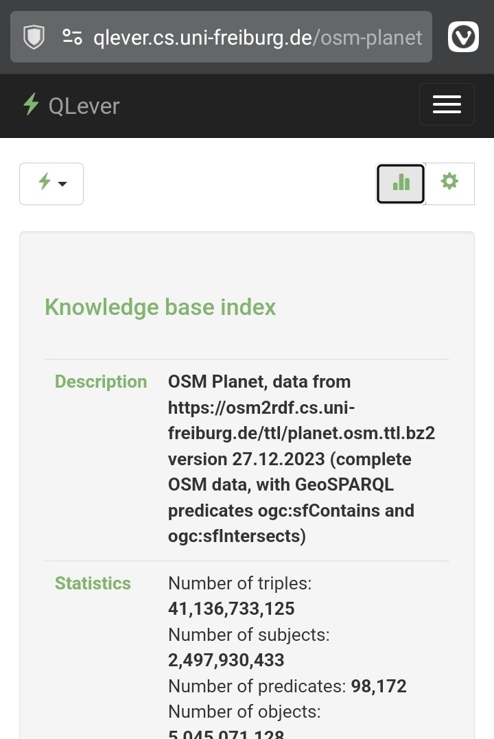
| OpenStreetMap + Wikidata |
|
|
| OpenStreetMap + Wikidata | Yes I have. The only concern that I have with QLever is that there’s a lag between OSM’s latest data update and when that new data can finally be queried. (It doesn’t even fetch the latest version of the Wikidata knowledge base. Instead, it creates a local periodic copy and then performs fast queries based on that periodic snapshot.) I’m not sure how long this lag is, but that’s why I’m still sticking to the Overpass API, at least for now. |
|
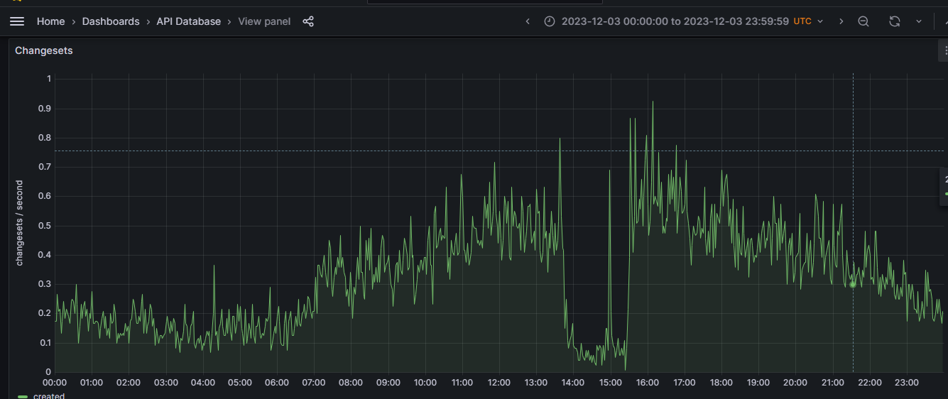
| OpenStreetMap Service Availability (2023-11-20 - 2023-12-20) |
I checked both
|
|
| Call for ideas from Microsoft | More support for public transportation data on OSM. Make it easier for any casual user to use, access and add new public transportation data. (I’m trying to build one here : https://github.com/altilunium/bisangkot ) |
|
| Utilizing the Power of Open Source Technologies: Mapping Tree Species at UP Diliman Academic Oval | Have you ever heard about open-data-based species location database projects, such as iNaturalist? While I can put my plant observation data on OSM, I usually put it there instead due to a more comprehensive species name database and image upload support. |
|
| All landcover mapped in the country of Belize. |
Beautiful. Keep up the good work
|
|
| Mapping under the trees | Really cool. Thanks for the info. 👍
|
|
| The story of agricultural groups | In Indonesia, we call it “Koperasi Unit Desa” |
|
| Places that mimic terrain or are shaped like something. (지형을 본땄거나 어떤 것을 형상화한 장소들) | Adding one more : |
|
| A Glossary of Tags for Landforms | Oh, last month, I discovered an alluvial fan near my relative’s hometown, but I don’t know how to tag it on OSM. Instead of using natural=sediment, how about a more direct tagging like natural=alluvial_fan? An alluvial fan is a specific and distinguishable type of sediment, whereas there are several other geographic features that can be categorized as sedimentation. |