dawidi
- Mapper since:
- July 18, 2007
Tobias Hoerburger, a.k.a. “dawidi”. Multi-purpose geek in Regensburg, Bavaria. Geocacher, xkcd-geohasher, photography enthusiast and all-year cyclist.
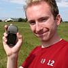
I first got a GPSr into my hands in 2000 (shortly after Selective Availability was turned off), for surveying well over a hundred anthills in a small forest for a local “club for the protection of ants” with my father. However, I had no way of downloading the recorded tracks and thus found the device rather uninteresting. In 2006, I realized the expensive “data cable” I needed was really just a serial port connector wired to three pins on the GPS’s back, and built such a cable to record my movements on a trip to Venice.
Since then, I have obsessively collected traces of all my outdoor movements non-stop since spring 2006 and initiated the mapping of Regensburg in August 2007 immediately upon learning about OSM. After a pause of several years, I started contributing edits again in the spring of 2012. My main GPS was a Garmin Vista from 2006 to 2009, and a Vista HCx ever since - loaded with the latest issue of Kleineisel’s OSM-topo map of Germany until 2013, and maps from the Freizeitkarte-OSM project since then. (I have been using my current GPS for over a decade, in freezing rain, in direct sunlight, in valleys and forests without cell coverage, with ski gloves, and all day for several days away from the power grid - would your shiny phone or tablet survive that too?)
I remember, in 1999 or 2000 in a situation where I was stuck with my bike in the middle of a highway=path;tracktype=grade7 due to a bad map, I thought: “Having a digital map on a GPSr on my bike would be way cool… there should be an online community where people share their own ways made from their tracklogs, like they share mp3s on Napster, but legally. On such a map any missing, superfluous or erroneous ways could be fixed instantly and everyone would profit from that.” - Guess what we have now. Thanks folks! :-)