RacingRalph
- Mapper since:
- October 07, 2009
Derzeit versuche ich einige Radwege und Mountainbike Routen im Grossraum Innsbruck einzupflegen. Würde mich freuen, wenn auch andere Mapper dabei mitmachen! Mehr Infos:
http://wiki.openstreetmap.org/wiki/WikiProject_Austria/Radwege#Radwege_in_Tirol
http://wiki.openstreetmap.org/wiki/Mountainbiketouren#Tirol
http://www.tirol.gv.at/themen/sport/radfahren/
Garmin Vista GPS handheld, mounted on bike. I use the fantastic openmtbmap.org Garmin maps for routing and navigation:

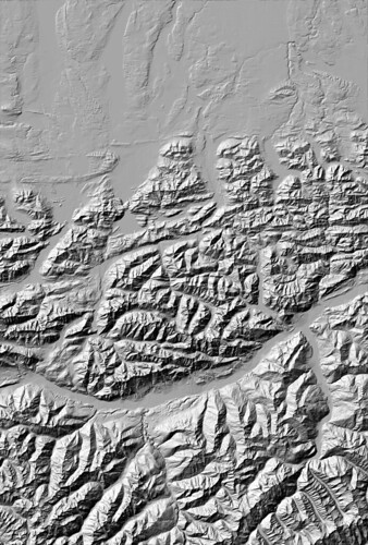
Based on SRTM (Shuttle Radar Topography Mission) data by the NASA.
Process to generate relief of SRTM data:
gdal_translate -of GTiff -co "TILED=YES" -a_srs "+proj=latlong" N47E011.hgt_ input_adapted.tif
gdalwarp -of GTiff -co "TILED=YES" -srcnodata 32767 -t_srs "+proj=merc +ellps=sphere +R=6378137 +a=6378137 +units=m" -rcs -order 3 -tr 15 15 -wt Float32 -ot Float32 -wo SAMPLE_STEPS=100 -multi input_adapted.tif warped.tif
hillshade warped.tif hillshade.tif -z 2
Auto Route generation in mapsource for a bicycle tour. Using the free openmtbmap, which is genereated from openstreetmap data:
