seav's Diary Comments
Diary Comments added by seav
| Post | When | Comment |
|---|---|---|
| A tale of two airstrips | That was interesting! |
|
| Places that mimic terrain or are shaped like something. (지형을 본땄거나 어떤 것을 형상화한 장소들) | There’s apparently a pond in Finland constructed to look like Finland: Hat tip to Ciarán Ferrie on Mastodon: https://mastodon.ie/@ccferrie/110931948206325668 |
|
| Cleaning up cuisines in Canada with JOSM | @watmildon, if you want to convert those values to something more general and something that’s more recognizable to users and tools/apps, I guess |
|
| Cleaning up cuisines in Canada with JOSM | I know that this isn’t a mechanical edit but I’d like to point out the danger that unless you have personally visited or checked out the status of a retail POI (i.e., is it still open?), cleaning up tags would update the “updated” date of the object and some recency QA tools might interpret that as as a POI that no longer needs checking. |
|
| Hundred millionth changeset submitted: some graphs and stats | I’m pretty sure it’s easy to spin a vandalism or revert edit positively. But I’m really happy that the changeset is in Africa and by a committed mapper who was nominated for an OSM Award in 2017. |
|
| Diversity in OpenStreetMap, Seeking your help on ideas for the Foundation | Hi, Mikel! I think addressing diversity within OSM and the OSMF would be a long-term activity and creating a working group or something similar is a good step to start the ball rolling. However, one thing I think the OSMF in particular can do to improve the Foundation’s membership diversity in the short term is to get on with implementing the modified fee waiver program that the OSMF members approved during last year’s AGM so that we can get more members into the Foundation and this will definitely improve diversity within the OSMF. The updated program aims to waive membership fees for people who have made “sizeable contributions” to OSM. However, what constitutes “sizeable contributions” is still left up to the MWG and the Board. So, I would recommend that the MWG/Board proceed with defining what this means even if the Diversity Working Group (or another body) is still not yet created. |
|
| A Hard Lesson, You Need Android 6.0 or Higher for the New Mapillary App | Google is deprecating Android 4 so it has been asking app developers to target at least Android 5 nowadays when apps are updated. |
|
| Disputed boundary tagging sprint (2019-03) | Regarding the question of where to draw the line down the slippery slope, I broadly agree with the line drawn up by johnparis in his extensive proposal to map disputed boundaries on which claimants we only recognize for As for the related question on what claims OSM should map (after all, China and Taiwan claim the whole of each other’s controlled territories), I think that should be another (lengthy) discussion. Baby steps… |
|
| Disputed boundary tagging sprint (2019-03) | Tiny nitpick: Spratly Is. is also claimed by Vietnam. |
|
| Tell me about your username | My username is simply a pleasant-looking not-a-real-word anagram of the initials of my full legal name. I’ve been using this as my online handle and username since around 1997 when I first started using the Internet. |
|
| The effect of the new iD release on restrictions | For developers looking for algorithms on how to support via-ways, you could look at this issue at the OSRM GitHub repository. TL;DR: you need to preprocess the routing graph. |
|
| POI Edits by Editor | This is just my personal practice but I use MAPS.ME to add bookmarks about new/updated/closed POIs when I am outside. Then when I get back home, I edit them using JOSM. I don’t use MAPS.ME’s editor because I tend to also fix the surrounding geometry and add other tags that MAPS.ME does not support. |
|
| Easily map individual parking spaces using the terracer plugin in JOSM | @DaCor, there would be no visual clutter because the tag is amenity=parking_space, not amenity=parking. |
|
| Welcome to the new Missing Maps | For some of the issues raised, I believe that a rising tide lifts all boats. While I understand the concern that MM gives the impression to OSM newbies that OSM is only about humanitarian mapping, I believe that this can be alleviated to a large degree by presenting the whole ecosystem of OSM as a short 15-minute lecture at the start of MM mapathons. This is certainly how we do our local events in the Philippines even if the event is focused on humanitarian mapping. |
|
| What comes first, Map or Database? Should we tell newbies the truth? | Whenever I do my “Introduction to OpenStreetMap” lecture, I always make sure to point out that the project is all about the geodata, and then pointing to numerous examples of people using the data in many interesting manners. I think this explains quite well that the project is much more than the map you see on the website. |
|
| admin boundaries: school districts in CA, US | For the quick key-value editing, the Level0 editor might be what you need. |
|
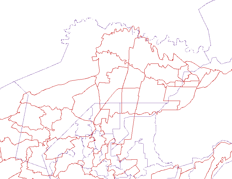
| Why am I against wholesale import of administrative boundaries from any 3rd party source for the Philippines | @SimonPoole, I don’t know where you read that Maning says that GADM’s license is compatible. He did say that “The license is incompatible.”. @Rovastar, I’m “Eugene” mentioned by Maning, and I actually tried to remove the “offset”. You can’t do that for the whole dataset with any consistency. If you go several kilometers north of the area shown above, the offset drastically changes as seen in the map below.
|
|
| Globalizing the name translation debate | @Stalfur, I also think that the original point also includes developing tools to use Wikidata with OSM data. There is no suggestion that we wholesale remove some name tags in OSM without having a concurrent usable tool in obtaining the data in those removed name tags. |
|
| Globalizing the name translation debate | I think the original point of the mailing discussion is, why not put your Vietnamese translations into Wikidata instead of in OSM? |
|
| map styles: Default OSM vs Google Maps | The question is, what is the purpose of the default map style? From what I understand, this style is the mapper’s style and is meant to show at a glance whether an area is already well-mapped or not. And at higher zoom levels, it tries to show POIs and other smaller details so that we can see if there are missing or outdated features. As such, it intentionally shows a huge amount of detail at various zoom levels. Comparing this style with Google Maps might not be such a good idea. We can probably look to it as an inspiration for certain design decisions, but that’s it. |