Loading...
Way: 22803308
Version #22
wikidata
Tags
| bicycle | yes |
|---|---|
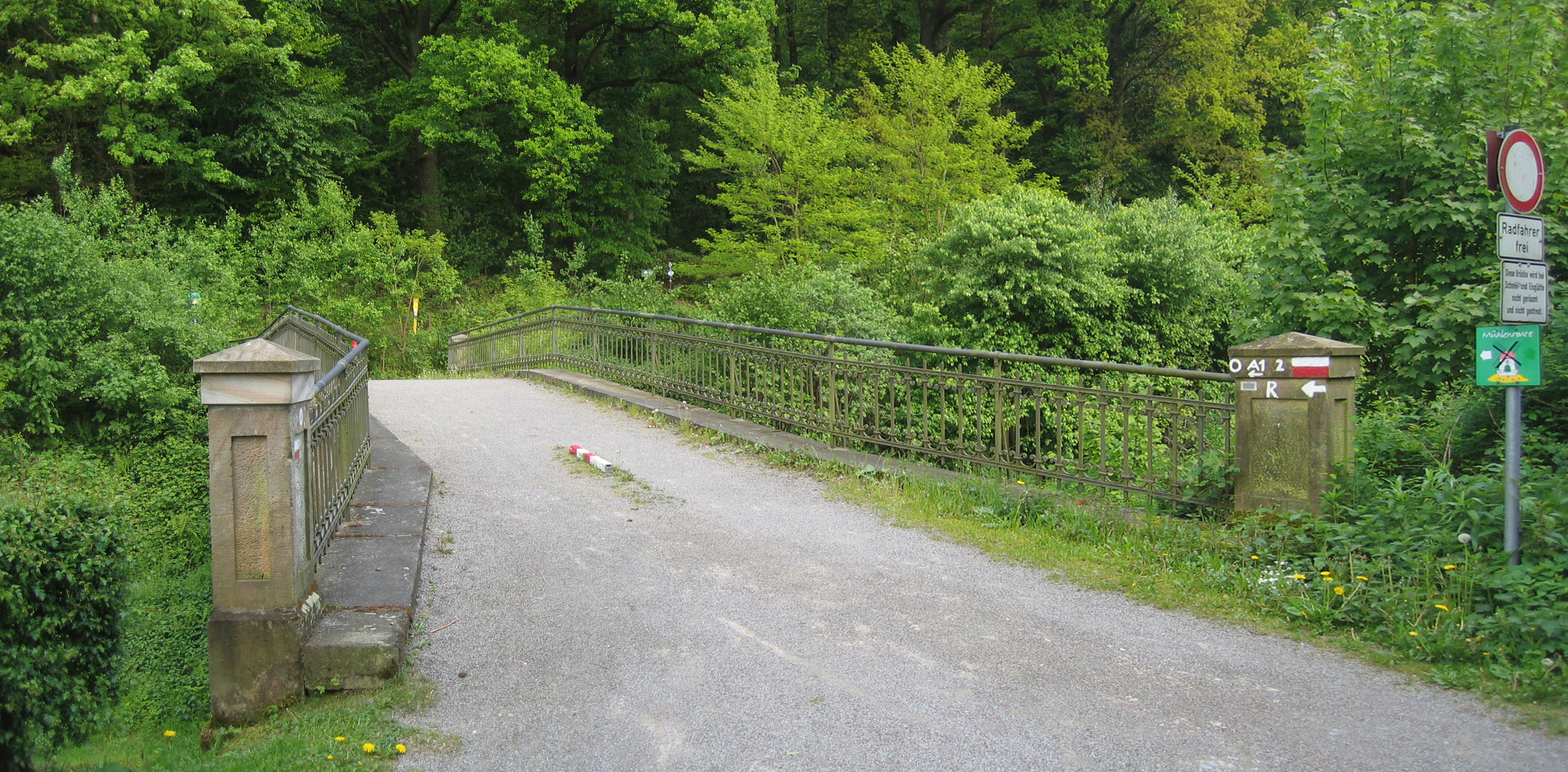
| bridge | yes |
| bridge:structure | arch |
| cycleway | no |
| foot | yes |
| heritage | 8 |
| heritage:operator | UntereDenkmalbehörde |
| highway | unclassified |
| historic | yes |
| horse | yes |
| layer | 1 |
| material | sandstone |
| maxspeed | 30 |
| maxweight | 3.5 |
| motor_vehicle | no |
| name:bridge | Hasenbrücke |
| operator | Deutsche Bahn |
| postal_code | 32289 |
| related:wikipedia | de:Liste der Baudenkmäler in Rödinghausen |
| sidewalk | none |
| source | https://upload.wikimedia.org/wikipedia/commons/a/a7/Panorama_Hasenbr%C3%BCcke.jpg |
| source:horse:no | https://www.vfdnet.de/images/Registered/NRW/Reitrecht/Amtsbl%C3%A4tter/Kreis_Herford.pdf |
| source:horse:yes | https://www.vfdnet.de/images/Registered/NRW/Reitrecht/Amtsbl%C3%A4tter/Kreis_Herford.pdf |
| surface | gravel |
| traffic_sign | DE:250; DE:1022-10 |
| width | 2.7 |
| wikidata | Q111522015 |
| winter_service | no |
Part of
10 relations
- Relation Kreis Herford - Tagestour 5 (Kulturlandschaft zwischen Elseaue und Wiehengebirge) (3030088)
- Relation BahnRadRoute Weser - Lippe (Hauptroute) (153809)
- Relation Wittekindsroute (3029758)
- Relation A1 Wandergebiet Bieren (3091704)
- Relation A1 Wandergebiet Bieren (3091704)
- Relation Mühlenroute (128220)
- Relation Wittekindsweg (63351)
- Relation Europäischer Fernwanderweg E11, Niedersachsen (W) (3418951)
- Relation Limberg-Nonnenstein-Weg (3089480)
- Relation RadKulTour Rödinghausen (3029724)
Nodes
4 nodes
- 245219341 (part of ways Zur Schirmke (231885719) and 904599904)
- 4426558203
- 3647606568 (part of ways 360154674, 360155002, and 904599904)
- 245219339 (part of ways 360154674, 22803309, and 904599904)
Welcome to OpenStreetMap!
OpenStreetMap is a map of the world, created by people like you and free to use under an open license.
Hosting is supported by Fastly, OSMF corporate members, and other partners.
| https://openstreetmap.org/copyright | https://openstreetmap.org |
| Copyright OpenStreetMap and contributors, under an open license | |