Loading...
Way: Ringstand 200 (369682806)
Version #8
add heritage website
Tags
| building | bunker |
|---|---|
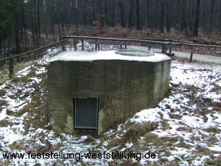
| bunker_type | pillbox |
| description | Ringstand Typ 58c; 7grad.org Nr.16a |
| heritage | 8 |
| heritage:operator | UntereDenkmalbehörde |
| heritage:ref | 11a |
| heritage:ref:gem | nikr0200011a |
| heritage:ref:inspire | DE_05166020_B_00011-001 |
| heritage:ref:lvr | VIE 125 |
| heritage:website | https://gisdata.krzn.de/files/Denkmal/Niederkr%C3%BCchten/DE_05166020_B_00011-001.pdf |
| historic | building |
| image | http://www.feststellung-weststellung.de/neue%20Bilder/ringstand_200a.jpg |
| location | overground |
| military | bunker |
| name | Ringstand 200 |
| old_name | transloziert, original einige Meter südlich der alten B230, heute A52 |
| start_date | 1944 |
Part of
1 relation
- Relation Maas-Rur-Stellung (15028602)
Nodes
Welcome to OpenStreetMap!
OpenStreetMap is a map of the world, created by people like you and free to use under an open license.
Hosting is supported by Fastly, OSMF corporate members, and other partners.
| https://openstreetmap.org/copyright | https://openstreetmap.org |
| Copyright OpenStreetMap and contributors, under an open license | |