
New hyper-detailed mapping in Uzice, Serbia
Posted by miroslavuzice87 on 30 January 2022 in English.Uzice is a town in the Zlatibor district, in the Republic of Serbia. According to the 2011 census report, there were 52,646 inhabitants.
It lies on the banks of the river Djetinje. The medieval ruins of the then very important city have been preserved. Uzice was the seat of the Partisan army in the fall of 1941. In 1946, the name was changed to Tito’s Uzice in honor of Josip Broz Tito, and the old name was returned in 1992.
Uzice is a major center of the metal and machinery industry and fruit growing. Administrative center of the municipality of the same name and Zlatibor district.
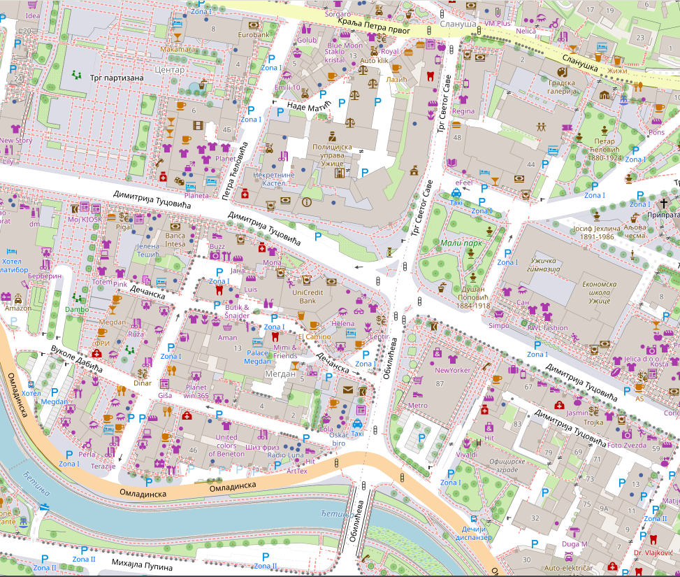
Just look at the difference, how it looks now & how it did look before the change was made to a map:

https://wiki.openstreetmap.org/wiki/Micromapping is a huge deal for me, I just love all the details u can enter into the map. Micro mapping or micro-mapping in OpenStreetMap (OSM) refers to the mapping of small-scale features. This may include mapping such objects as a building entrance, as well as the footway and steps leading to that entrance. Another aspect is to improve the visual representation of scenery for 3D for example. Therefore this includes improving geometries (buildings, land use, …) but also adding very small objects such as city furniture (street lamps, benches, …) and village green (trees, hedges, …)
Pros and cons of micro mapping;
Pros:
- allows 2D routing
- helps in indoor positioning systems
- brings a lot of details to the DB
- If done properly it will ease mapping in previously empty regions
Cons:
- more time consuming to enter data for mappers
- requires more accurate information (sometimes consumer GPS is not sufficient)
- sometimes makes it harder for beginners to alter the data
- If it is required in some proposals on osm wiki, it may discourage people from using it (technical) increase of volume will increase requirements in processing power
Click on image bellow to see map of Uzice in OSM:
Discussion
Comment from cytryn on 30 January 2022 at 21:00
Indeed, the result looks nice at first glance. However the way you obtain it is totally incorrect, at least where street areas goes.
Forcing the street areas to be rendered by using combination “highway=*” + “area=yes” is definitely the wrong approach, since “highway” objects corresponds to the road centerlines and they are navigable routes by definition. So used this way will cause weird and unpredictable behavior of routers which will try to navigate along such highway boundaries (an example).
This is typical tagging for the renderer (you sacrifice data quality just to obtain nice-looking picture) and should be replaced with the correct area:highway tagging scheme. Tagging railroad areas as natural=bare_rock has the same drawback - it does not refer to the reality.
So, concluding, micro-mapping - YES, but the data entered should represent features as they really are on the ground.
Comment from ChristianA on 31 January 2022 at 07:02
Very impressive mapping; good work!
Comment from miroslavuzice87 on 31 January 2022 at 07:37
Thank you ChristinA so much!
Comment from miroslavuzice87 on 31 January 2022 at 08:02
Thank you cytryn as well. Thank you for your suggestion. All areas that are drawn are with tag access=no, which prevents routing through that. However, u send an example where routing is too short, point A and point B are too close, in that case, routing will go through the area sometimes, and on this area specifically, I intentionally put foot=yes tag but will remove it since it can create mistake like that.
area:highway is very familiar to me but is still in an experimental stage and it does not render on the map, once is completely in use and approved I will easily change every area with area:highway.
Comment from CRCulver on 6 February 2022 at 17:33
area:highway does already render in map apps in wide use like OSMAnd, and the area:highway tagging has long been considered mature already across multiple countries.
Keep in mind that the map at openstreetmap.org is just a tech demo, not a real consumer product. It lacks support for rendering many tags that have been well-established and widely used for a long time now.
You shouldn’t base your tagging choices on what produces the desired rendering on the openstreetmap.org map.
Comment from Circeus on 7 February 2022 at 13:40
I’d agree with Cyrtin that using highway areas in this fashion is inappropriate. The very fact that additional tags have to be retroengineered to avoid disrupting routing is proof that this is improper
In the opposite direction, I think it wholly inappropriate to crisscross highway=footway on top of something already tagged as a footway area. It manages to simultaneouly bevisually horrendous and geographically inaccurate.
Sadly, there is no system, not even a de facto one, for mapping extremely broad steps such as those at the southern end of Трг партизана. My personal solution has usually been to use a barrier=steps on either a line or an area. The former can be used like barrier=kerb and works especially well when one or two steps clearly bisect a footway area, the latter is messier as there is no easy way to indicate directionality for areas…
Personally I’m not a huge fan of mapping paved areas between buildings and the road, but this is kind of a rock-and-a-hard-place issue rather than an accuracy one. You see, when those areas are mapped, it becomes increasingly difficult to quickly select the desired feature in iD because all edges are joined and overlapping at all points (thankfully this is no longer an issue with borders, but I’d rather we not start doing relations for everything as a solution!). However, I reserve fear greater amounts of loathing for the practice of mapping sidewalks as footway lines… which is also done here at the same time!
Comment from adam342 on 4 June 2022 at 09:35
Thanks for sharing amazing information keep posting. isse.nu Great article… Thanks