
Improve OSM Improved - and now with Turn Restrictions
Posted by mvexel on 18 December 2015 in English.I am happy to announce that Improve OSM, the suite of open source Telenav tools that help us fix OSM based on vast amounts of GPS data, is completely redesigned and expanded. We made the web site much easier to use. We combined the existing JOSM plugins into one new plugin. And as of today, we have an entirely new category of fixes: missing turn restrictions. I will talk about all of these changes in this diary entry. A lot to cover so let’s get started!
The new Improve OSM web site
We redesigned the Improve OSM web site completely. Instead of separate maps for each type of error, all errors are now displayed on one map. You can turn each type on and off in the layer panel. You can also control the filters for each type there.

What’s even better (I think) is that you can now perform the entire fixing workflow from the web tool, including resolving the error as fixed or invalid. (You used to need the JOSM plugin to change the status on items.)
The new plugin
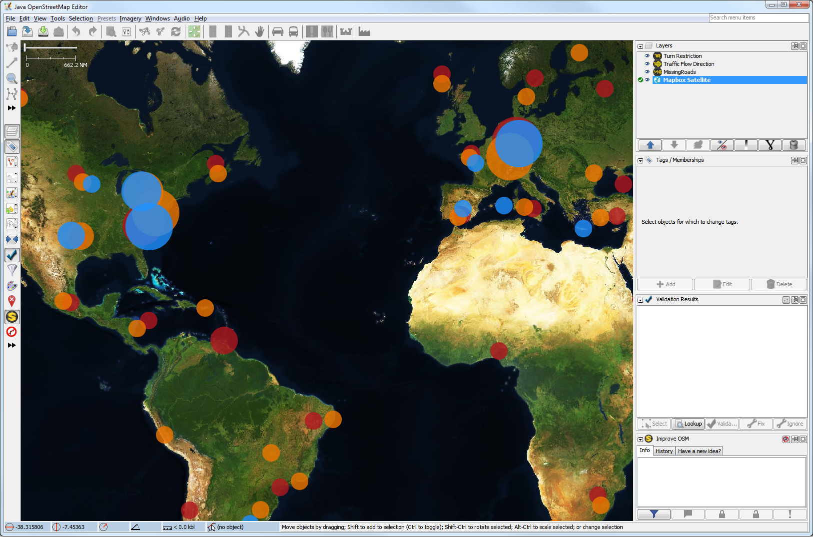
We released two Improve OSM JOSM Plugins so far: MissingRoads and TrafficFlowDirection. With more error types in the pipeline, it made sense to combine all Improve OSM functionality into one plugin. This new plugin is simply called ImproveOSM. The functionality is largely the same as the previous separate plugins. Each error type still has its own layer. At low zoom levels, the results are clustered:
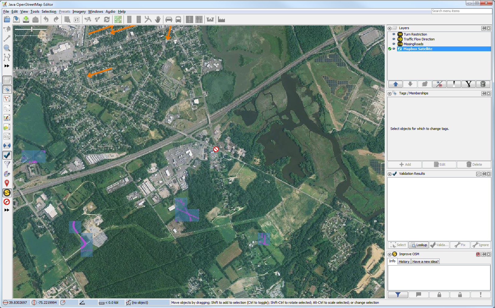
When you zoom in, individual errors become visible:
Please see the diaries I wrote before on the Missing Roads and Traffic Flow Direction layers to learn more about how to work with them.
If you looked closely, you can see that we added a third layer. More about that next.
New Improve OSM type: Turn Restrictions
If you collect a lot of GPS traces like we do, all sorts of interesting patterns appear. You have seen some results with the Missing Roads and Traffic Flow Direction plugins. It gets even more interesting if you consider trip counts over more than one road segment. For example through an intersection. If you consider the relative amount of trips for each possible turn, it is possible to derive which turns are likely prohibited. Compare that against existing OSM data, and voilà - here is our next Improve OSM project!
(In a future diary I want to go into the technical details of turn restriction detection. Right now I will focus on the functionality of the new layer.)
Mapping Turn Restrictions
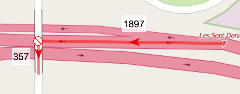
If you activate the Turn Restriction layer in either the Improve OSM web site or the JOSM plugin, you will encounter suggested turn restrictions like this one here:

I like to edit Turn Restrictions in JOSM myself, with the help of the TurnRestrictions plugin, but it can be done in iD as well. So I click ‘edit in JOSM’ to load the area in JOSM:

You see that I selected the suggested turn restriction from the Improve OSM Turn Restriction layer. You can also see that I loaded Mapillary data using the Mapillary plugin. Street level imagery can be a great help verifying turn restrictions, and in this case the selected Mapillary image revealed that there is indeed no left turn allowed in this case:

Image source: Mapillary
While the plugin suggests a no-left-turn restriction, I prefer to map this as an only-straight-on restriction, because that is closest to the actual sign on the road:

With the new turn restriction in place I can upload the changeset. I use #improveosm in the changeset comment and I encourage you to do the same:

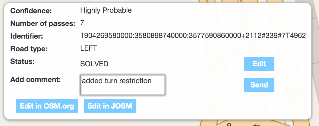
And finally I can choose to either mark the case as fixed in the web tool or straight in the plugin. I opt for the web tool:
And that’s it!
False positives?
We are still tweaking this algorithm and you may see false positives. Please mark them as ‘invalid’ if you see them. If you think you see a pattern, don’t hesitate to use the feedback links in the plugin or on the web site to let us know. You can also just email me at martijnv@telenav.com.
Sometimes, the algorithm unveils unexpected other map errors as well. Looking at this situation where the algorithm detected a missing left turn restriction:
It would seem that this is a viaduct, so there would be no turn to make at all. But it turns out that the bridge and one of the motorway segments passing under it were connected:

So definitely something you would want to fix!
Happy Holidays and Happy Mapping!
I hope this gives you some interesting things to map over the holidays (in case you celebrate). Let me know what you think! I will be back in the new year with a more detailed post on how we detect turn restrictions. The team will also start looking at any feedback that comes in then.
Discussion
Comment from RobJN on 19 December 2015 at 12:13
Amazing work :-) Great to see the improvements to the website and unifying the JOSM plugins is a great step (was starting to get confusing).
Comment from k1wi on 19 December 2015 at 14:30
Amazing tool!
Any updates on the roundabout detection for oneway errors?
Comment from mvexel on 19 December 2015 at 17:54
anewuser1: I’ll look into HTTPS download. As a workaround, you can use the web site for now..
Comment from mvexel on 19 December 2015 at 17:56
k1wi - Not fixed yet. I’ll see what I can do. We’re all on holiday break now so it will be 2016 for sure though.
Comment from stephan75 on 19 December 2015 at 19:12
Many thanks for your efforts, Martijn!!
Can’t wait to try the new plugin when a bit more time available …
Is it possible to give all JOSM user a hint that any loaded plugin for missingsroads and trafficflowdirection are deprecated now by teh new plugin?
Is JOSM able to “delete” the old plugins after a hint to the users?
Comment from Jonathan ZHAO on 21 December 2015 at 19:14
Great works!
Comment from martiensch on 21 December 2015 at 19:59
Nice addition, Martijn. It appears that turn restriction of the type ‘only__’ are not recognized correctly by the tool. For example: id: 3227829780000:231505290000+6543#145#1T11188 josm: http://127.0.0.1:8111/load_and_zoom?left=8.800585269927979&top=53.054178428871325&bottom=53.05258880249541&right=8.805735111236572
Comment from andrewpmk on 23 December 2015 at 19:29
It seems like the vast majority of turn restrictions on ImproveOSM in the Greater Toronto Area are false positives. Most of them are u-turns which few people are making but as far as I can tell most of them have no sign prohibiting them. Most of the turn restrictions in Toronto are only at specific times and you need to do a survey (or use Mapillary) to find them. Also I found a strange false positive at Lake Shore and Strachan in Toronto where there is a right turn ramp westbound but it looks like there is no sign prohibiting turning right without the right turn ramp (see Mapillary). I did find a highway overpass that was incorrectly glued to a highway at Highway 403 and Highway 24 near Brantford though, which I fixed.
Comment from Baloo Uriza on 28 December 2015 at 19:53
What do the numbers presented on the detected turn restrictions mean?
Comment from RicoElectrico on 4 January 2016 at 20:39
What is going on in here? It seems that this is a false positive even though high confidence is reported. I checked other sources and they agree with OSM.
http://improve-osm.org/#53.5882445,14.8189688,16/OPEN/true,1-1-0/true,1-1-1/true,0-0
Comment from jinalfoflia on 27 January 2016 at 12:27
@mvexel I have a question regarding the field
Number of passes.What does it actually signify? How is it related to the turn-restrictions?