OpenStreetMap

ke9tv's Diary

Recent diary entries

At long last, I’ve done a complete pass over municipal and CDP boundaries in New York State. Barring errors and omissions (I daresay there must be some) every incorporated community and every CDP in the state has had its border checked against NYSGIS Civil Division Boundaries and TIGER/Line 2021 respectively, almost always resolving conflicts in favour of the former. All have place=* nodes representing them, with the node a label member of the boundary relation.

Populations are updated as of the 2020 Census. GNIS, FIPS, NYS SWIS, Wikipedia and Wikidata links are provided.

Most of the remaining work that I’d have to do before I consider the job to be done has to do with the tagging on the place=* nodes. Right now, they’re a hodgepodge. Most of them came in from the TIGER import of 2008 with place=* representing their form of government. This is NOT an indication of the significance of the place. Brentwood, Long Island, a bustling community of over 60,000 souls, is tagged place=hamlet because it does not have home rule. Geneva, a sleepy lakefront village is 3400 inhabitants or so, is tagged place=city because it has a city charter.

For a first stratification, I’d propose simple thresholding on population:

  • City: At least 50000 inhabitants.

    This would encompass New York, Buffalo, Yonkers, Rochester, Syracuse, Albany, Schenectady, Utica, White Plains and Troy. The largest communities not to make the cut would be Niagara Falls and Binghamton. The ‘city’ tag would also fall on the suburban communities of Ramapo, Amherst, New Rochelle, Cheektowaga, Mount Vernon, Brentwood, Clay, Hempstead, Town of Tonawanda, Levittown, and Irondequoit.

  • Town: >4800 inhabitants.

    This was a somewhat arbitrary cutoff. I wanted it to include Saranac Lake (pop. 4887) because that community has the only hospital for many miles around, and has an airport with scheduled, albeit infrequent, service. The threshold could be set higher if the manual work of identifying the sites of such facilities as hospitals, universities, airports, major markets, and so on were to be attempted, but I’d consider that to be Out of Scope.

  • Village: >1000 inhabitants.

    Totally arbitrary, there’s a long tail and you have to cut it off somewhere.

  • Hamlet: Smaller.

There are some tagging anomalies that also need attention.

  1. For townships that didn’t have an identifiable population center with the same name as the township, I reimported label nodes from GNIS. I tagged these with not:place=town place=region to indicate the fact. I seleted region because it was available as a JOSM preset, but I now realize that the Wiki mentions place=municipality, and that seems to be a better fit. I’ll make this change as well.

  2. The only correct use of place=suburb among the objects I’ve examined is that the five boroughs of New York City fit the OSM definition. There are other communities that are mistagged place=suburb because they are near to a major city, but that’s not correct tagging.

  3. CDP’s that don’t correspond to identifiable unincorporated communities (for instance, the ones that represent resident university campuses) are tagged place=locality and this should most likely be left alone. CDP’s that represent portions of a city or surround subdivisions, I’ve retagged place=neighbourhood and these too should be left alone.

  4. Somewhat controversially, I’ve left boundaries of most CDP’s as boundary=administrative. I know for certain that the ones in Nassau County, at the very least, actually are administrative subdivisions without home rule - the towns of Hempstead, North Hempstead, and Oyster Bay all designate hamlets, and often promulgate things like parking regulations and zoning ordinances by calling out the hamlets by name rather than repeating the boundaries in each piece of legislation. I figured that in doubtful cases, it’s better to show the boundaries than to hide them.

  5. Even more controversially, most incorporated communities have an office=government node taking the administrative role, and showing the location of the town administration (the town hall or equivalent) and contact information for general inquiries (usually the town clerk’s office). This is a total abuse of the tag - it’s supposed to identify the capitAl, not the capitOl. Nevertheless, it provides useful information, and I believe that instead of deleting the relation members wholesale, it would probably be better to rename the role.
    Does anyone think it would be worthwhile to work up a proposal for a seat role (or something similar - the Naming of Names is an area that I try very hard to steer clear of)?

Use of New York State GIS data

Posted by ke9tv on 20 July 2020 in English.

(Disclaimer: I am not a lawyer, and none of this is intended to be legal advice. I do, nevertheless, consider myself to be an informed layman - and offer this analysis as a starting point for research into the legal status of GIS data in New York, with citations to relevant law, court cases, and commentaries from both sides of some of the controversies. I do not purport it to be an unbiased analysis; as and OSM contributor and otherwise as an ‘open sourcerer’, I have strong personal opinions regarding the purported ownership of factual information. I nevertheless attempt to present the law as it stands, even if I sometimes make the Dickensian observation that “the law is an ass.”)

What’s up with GIS data in New York?

GIS data originating from government agencies have, for about twenty years, been subject to considerably uncertainty and risk. This largely stems from the fact that in many jurisdictions, the mantra that “government should be run like a business” has led to expectations that state and local GIS departments should support themselves on user fees, rather than from the general fund. The most lucrative source of these fees has been the “multiple listing services” used by real estate agents to exchange data about houses on the market. These services often pay handsomely, far in excess of the cost of reproduction, for the maps of tax parcels. These provide the agents with the boundaries of properties listed for sale.

It is worth noting that in this discussion, I refer to State and local data. It has always been held that works prepared for the US Government by a government employee engaged in the performance of official duties are in the public domain. Works produced by contractors, depending on the terms of the contract, may be protected by copyright. Ordinarily, in this case, the copyright holder will be identified prominently. Those who use public data promulgated by a Federal agency have little to fear.

With the advent of broad use of the Internet in the 1990’s, more and more GIS data belonging to the States have been exchanged in digital form. This exchange has meant that the cost of reproduction has fallen to nearly nil, and the sale of such data is openly meant to defray the cost of the original work. The courts have had a mixed reaction to this, and the way that it tends to come into apparent conflict with the Freedom of Information laws passed in the various states.

For data belonging to the counties, New York State endures a particularly murky legal situation. In particular, Suffolk County was a bellwether in attempting cost recovery for its production of the tax maps.

The Suffolk County case - origins

In 1971, the county separated its Real Property Tax Servicce Agency from its Department of Public Works, and provided a USD2.8 million initial funding resource in the form of a cost transfer from Public Works for the preparation of the tax maps. At the time, the maps were drawn by skilled drafters in pen and ink on plastic film. In 1974, the first edition of the tax maps was completed, and the county filed for copyright registration on the maps.note-1 Upon securing the copyright, the county commenced negotiatons with Real Estate Data, Inc. (REDI) to reproduce the maps in paper form and market them to the general public. The eventual agreement resulted in a USD25,000 annual payment from REDI to the county, an additional payment of 5% of REDI’s gross sales, and a promninent display of Suffolk County’s copyright notice in every edition of the maps.

In the early 1980’s, REDI changed corporate control several times. As a result, the court papers variously refer to REDI, Information Systems and Services, Inc., Thomson-Ramo-Wooldridge (TRW), Experian Data Services, First American Real Estate Solutions, and possibly others. (Astute readers will note that several of these names are associated with one of the ‘big three’ US credit-reporting bureaux. The corporation was unsympathetic defendant even at the time of the court case discussed here.) After one of its changes of control, the agreement allowing it to copy and distribute tax maps was abrogated or allowed to lapse. The specifics are unclear, but all parties substantially agreed that no agreement was in force by the mid-1980’s.

With no agreement in force, REDI continued to sell copies of the maps, but no longer received updated information from the county. The county was concerned both about the loss of revenue and the complaints that it received about obsolete maps, and in 1999, filed suit against Experian for declaratory and injunctive relief, and for monetary damages for copyright infringement. The cited article note-2 details a timeline of the case.

The Suffolk County case - the defense

Experian offered no argument, at least in the initial proceedings, that it had not made and distributed copies of the tax maps. Instead, it moved to dismiss the case, on the theory that as a matter of both public policy and law, the county could not own a copyright on the maps. The US District Court for the Southern District of New York disagreed, and ruled that nothing in US copyright law forbade a State or local government, as opposed to the Federal government, from registering, owning and prosecuting a copyright.

Experian moved for reconsideration, and presented the argument that, while Federal law might not forbid a State from enforcing a copyright in its documents, New York’s Freedom of Information Law (FOIL) did forbid it. It cited advisory opinions offered by the New York State Committee on Open Government note-3 (and the court cases referenced therein) that argued that failing to disclose the tax maps or requiring contracts restricting their public redistribution ran against the FOIL. Upon analysis, the court agreed, and dismissed the county’s case. The county appealed.

The Suffolk County case - the decision

The Second Circuit court of appeals decided the case, issuing its opinion on 25 July 2001. note-4

Since the ruling was on a motion to dismiss, there was no finding of fact. All of the court’s opinions are on matters of law.

The defendant’s first argument was that the county had failed to state a claim. As the court observed, “The issue is not whether a plaintiff will ultimately prevail but whether the claimant is entitled to offer evidence to support the claims” - construing all the facts in the light most favorable to the claimant.

The court found that the Copyright Act of 1909 had no restriction on state’s asserting copyright over their works for hire. (For example, a state or local government, could commission a piece of public art, and retain copyright over it if it was contracted under a work-for-hire agreement.) The tax maps could be “original works of authorship” and protectable under copyright.

Copyright law requires that copyright be claimed over an “original work of authorship.” Bare facts that do not originate with the author of the work do not qualify, and the “sweat of the brow” in compiling them does not by itself imbue them with originality. Rather, a work is copyrightable only if “it possesses at least some minimal degree of creativity.” note-5 First American had argued that the tax maps contained no original protectible elements, and in the alternative, argued that any original elements were not subject to copyright protection befcause they were dictated by state law and regulations. Suffolk had responded that “tax maps contain a substantial amount of original material, research, compilation and organization wholly original with the plaintiff.”

The court found that it needed to focus on “the overall manner in which [the plaintiff] selected, coordinated, and arranged the expressive elements in its map, including color, to depict the map’s factual content.” (What this focus means in the context of GIS data is surely not clear to me!) It found that Suffolk’s allegation was sufficient to present a question of fact for a jury to decide. Alas, its phrasing was atrocious: “The District Court thus correctly found that Suffolk County has sufficiently alleged that its work is protected.” (More on this later!)

The defense had also presented the argument that New York’s FOIL abrogated Suffolk’s copyright, The State also intervened as amicus curiae, asserting its interest in the open sharing of the maps. In a lengthy argument, the Court concuded that the statutory language of FOIL was in fact silent as to the operation of coyprights. It further concluded that the advisory opinion of the Committee on Open Government should be accorded no deference, since it was advising on the operation of Federal copyright law (over which the Committee had no advisory power) and not on the State’s FOIL (which had already been dispensed with as being silent on copyrights).

Finally, the defense had argued that the tax maps were in the Public Domain from their inception. They are edicts of government, the defense argued, by analogy to legislative statutes and judicial opinions. The court found that the determination turns on two considerations: whether the entity that created a work needs an economic incentive to create or has a proprietary interest in creating the work, and whether the public needs to have notice of a particular work in order to have notice of the law. The court found the first consideration to be a matter for the trier of fact - the county was, at the very least, entitled to present evidence that the economic incentive of copyright was necessary for the maps’ creation. The court found the ‘fair notice’ concern to be irrelevant, since any individual required to pay property tax surely had access to both the law and the relevant map.

What was left, therefore for the District Court to decide was the the extent to which the tax maps were original (rather than compilations of fact with decisions guided strictly by regulation), and, should they be found to be original, the extent to which the economic incentive of copyright was needed as an incentive for their creation. It remanded the case to the District Court for further proceedings consistent with the opinion.

Following this judgment, the parties settled. As far as I know, the settlement terms were undisclosed. (If that is the case, an argument could be advanced that the failure to disclose them could itself be a violation of FOIL.)

The aftermath of Suffolk County

The state government has continued to assert that Suffolk County’s position is inconsistent with the Freedom of Information Law and the Federal copyright law, correctly pointing out that certain relevant facts were never determined by the lower court:

On appeal, the Second Circuit Court of Appeals held that in general, New York State, local government, and Suffolk County may claim a copyright protection under the Copyright Act. In contrast to the Federal Government, which is prohibited from obtaining copyright protection for its works (17 USC §105), the Second Circuit found that “the Copyright Act is silent as to the rights of states or their subdivisions” and that “[b]y specifying a limitation on ownership solely against the federal government, the Copyright Act implies that states and their subdivisions are not excluded from protection under the Act.” County of Suffolk v. First American Real Estate, 261 F.3d 179, 187 (2nd Cir. 2001).*

Due to insufficient evidence, however, the Second Circuit remanded the matter concerning whether the maps were sufficiently original and creative to qualify for copyright protection, or whether the content and the form of the maps were dictated by state law and regulation and thus not subject to copyright protection. Further, the Second Circuit opined, it would be for the District Court to determine whether the tax maps were in the public domain from inception, and thus outside the coverage of the Copyright Act. To make this determination, the District Court would have to consider, most importantly, whether the County needed the economic incentive of the Copyright Act to create the maps, or whether it had adequate incentives or obligations to produce their respective materials.

The Committee further went on to advise:

Conditioning the release of copies on contractual agreements governing future treatment of the copies, in our opinion, would thwart the very purpose and intent of the Freedom of Information Law. It is our belief that when materials are accessible under the Freedom of Information Law, upon receipt of the appropriate fee, they must be released to the applicant without restriction. Accordingly, in keeping with the Second Circuit decision in County of Suffolk, we advise that it is permissible for the County to notify the applicant that the materials may be subject to copyright protection, but that the County cannot condition access on a contractual obligation pertaining to redisclosure of records accessible to any member of the public.

and the opinion also addresses the fact that it is impermissible to use reproduction fees to cover anything but the cost of reproduction:

… although compliance with the Freedom of Information Law involves the use of public employees’ time, the Court of Appeals has found that the Law is not intended to be given effect”on a cost-accounting basis”, but rather that “Meeting the public’s legitimate right of access to information concerning government is fulfillment of a governmental obligation, not the gift of, or waste of, public funds” [Doolan v. BOCES, 48 NY 2d 341, 347 (1979)]. note-6

It has continued to issue advisory opinions of a similar nature as recently as 2015. note-7

Nevertheless, much of the press had taken the Suffolk County decision as a statement from the Second Circuit that tax maps are protected by copyright (a decision that it never reached). In fact, I vaguely recall a case from about a decade ago (to which I have mislaid the citation) in which New York City asserted similar claims against a copyright defendant, and the lower court took as given the misreading that tax maps are protected by copyright, finding the defendant liable on the pleadings, since the fact of copying was uncontested. (The case was mooted before an appeal could make its way through the system by the passage of New York City’s Open Data Law note-8).

Most New York counties, in this legal situation, continue jealously to guard their cadastral data in the hopes someday of securing significant cost recovery through licensing revenue.

What does all this mean for OSM’s use of New York Government data?

Despite all the legal turmoil, the prospect for using New York government data in OSM is actually fairly bright.

Data produced by and for the New York State government and listed in the gis.ny.gov data catalogue are pretty much fair game. The state government has consistently held for more than two decades that its data are public (with certain narrow statutory exemptions related to confidentiality and homeland security) and that they are free to all comers. Occasionally, the agency that produced an specific data set will request acknowledgment as a courtesy, and we can certainly satisfy that request on the Contributors page.

New York City’s data are also fair game, owing to the sweeping scope of its Open Data Law, which also leaves little room for the city to escape its obligation to make its operational data open and free to share.

Cadastral data, and data in general from the individual counties apart from New York City, is a mixed bag. The state has requested that the counties make parcel data available, but the response from the counties has been slow. As of this writing, 21 counties have resolved to make their tax parcel data public.

In addition, New York State has asserted that it has an unquestioned right to publish data about the parcels that it owns in allodium. (New York is the sovereign; it cannot own parcels in ‘fee simple’ since there is no superior title to which it answers.) It therefore publishes state-owned parcel data for all 61 counties.

I had previously had reservations about the legality of importing New York’s address point data because the address points were supplied by the counties, and in many cases were derived from parcel centroids. (If the parcel boundaries, devoid of other metadata, are the subject of copyright, why not their centroids?) I therefore counseled that people should proceed with caution in the forty counties that have not agreed to share their parcel data. My fears have been dispelled by a recent e-mail sent by Frank Winters to an OSM contributor, confirming that the data may be used without restriction or license for any lawful purpose. We can safely presume that the state government would not offer rights that are not theirs to give.

We should, as a project, retain a copy of Mr Winters’s e-mail including metadata, against any future inquiries regarding the data from gis.ny.gov. What is a proper repository for this messsage?

Given the legal uncertainty, extreme caution is still needed for county and municipal data outside New York City that have not been blessed by NYSGIS!

A final remark

People searching OSM contributions for my user name (ke9tv) will find the occasional parcel of public land in which I cite ‘XXX county tax rolls’. In all such cases, either the given county is one of the 21 that have given permission, or the tax rolls were used as one of multiple data sources in an effort to resolve boundary inconsistencies. In all cases where the tax rolls were consulted, the parcels were redrawn before uploading and there will be at least hairline differences between OSM’s copy and the county’s. Nothing remains of any artistic decisions made by the person who produced the original map. Nor does anything remain of the selection, sequence and arrangement of the data, since only individual parcels were extracted and any selection was mine alone. Since US law recognizes no copyright on the bare facts, I believe myself to be on an entirely firm legal footing.

Notes

note-1. note-2. Most of the factual account of the prosecution history of the case derives from Penny Wells LaValle, Tax Maps and the Legend of the Dragon Slayer. _Geographic Information Systems Technology News 3:_2 (Fall/Winter 2001).

note-3. The New York State Committee on Open Government has a name that sounds as if it might be an NGO, but it is in fact an agency of the Department of State responsible for overseeing and advising the government, the public and the media regarding New York’s Freedom of Information, Open Meetings, and Personal Privacy Protection Laws.

While its opinions are advisory in nature, the Executive Branch offers them extreme deference (partly because most members are members of the administration; the Lieutenant Governor, the Secretary of State, the Director of the Divison of Budget and the Commissioner of the Office of General Services serve ex officio; four more members are appointed by the Governor, while one member is appointed by each house of the State Legislature). The opinions may be presumed, absent evidence to the contrary, to be the official policy of the State.

County and local governments, as we see here, are more inclined to reject the Committee’s advice and challenge it in court, as we see here.

Relevant opinions presented to the District Court in relation to the Suffolk County case include:

  • Robert J. Freeman, Executive Director, New York State Committee on Open Government, letter to Kenneth W. Lovett, President, Virtual Information Systems, Inc., 5 January 1993 FOIL-AO-f7507. (opining that the contents of a GIS system are “statistical or factual tabulations of data” and thus not exempt from FOIL)

  • Robert J. Freeman, Executive Director, New York State Committee on Open Government, letter to Kenneth W. Lovett, President, Virtual Information Systems, Inc., 7 May 1997. FOIL-AO-f10072 (specifically opining that Suffolk County’s practice of charging a reproduction fee of USD4.00 per map was both in excess of the cost of reproduction and inconsistent with the FOIL, and moreover advising that the county could not skirt the issue by invoking the “unless a different fee was established by law” exception, since a mere committee of the county legislature did not have the power under statute to impose such a fee.)

  • Robert J. Freeman, Executive Director, New York State Committee on Open Government, letter to Robert N. Brower (Cayuga County Planning Board), 29 December 1998 FOIL-AO-f11230. (advising that the FOIL may require transmission of computer records in machine-readable form, while not requiring that new software be developed or new data entry conducted to produce such records, and urging that the Legislature consider adding language to the FOIL to require that computer databases be designed to provide easy redaction of private or security-sensitive information, so that FOIL requests can be answered without reprogramming.)

note-4 County of Suffolk, New York, v. TRW. 261 F.3d 179 (2001).

note-5 Feist Publ’ns, Inc. v. Rural Tel. Serv., Co., 499 U.S. 340 (1991)

note-6 Camille S. Jobin-Davis, Assistant Director, New York State Committee on Open Government, letter to [redacted recipient], December 19, 2005 FOIL-AO-15695

note-7 Robert Freeman, Executive Director, New York State Committee on Open Government, e-mail to [redacted], 6 February 2015 FOIL-AO-19246

note-8 New York City Local Law 11 of 2012.

note-9 Frank Winters (Geographic Information Officer, New York State Office of Information Technology Services), e-mail to Skyler Hawthorne, 17 July 2021, copy (with metadata) mirrored at https://kbk.is-a-geek.net/attachments/20200719/winters_20200717.txt

A town line in the Catskills

Posted by ke9tv on 6 December 2019 in English.

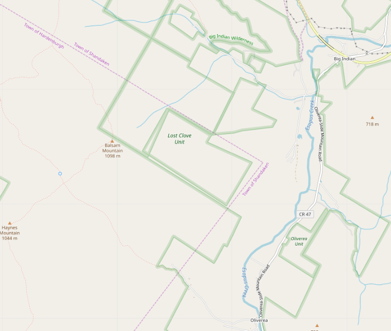
This post is intended to provide (rather too much) detail into my thinking as I attempt to synthesize several conflicting data sources into a ‘best guess’ drawing of an indefinite border between two townships in the Catskill Mountains of New York.

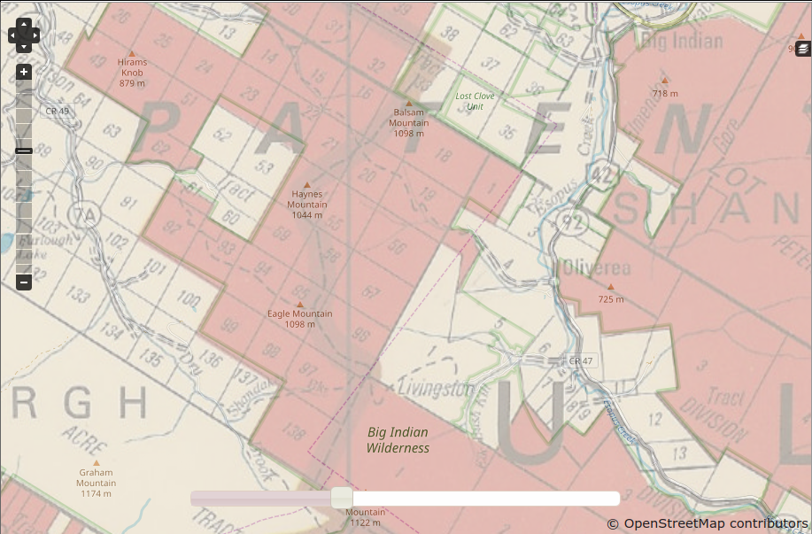
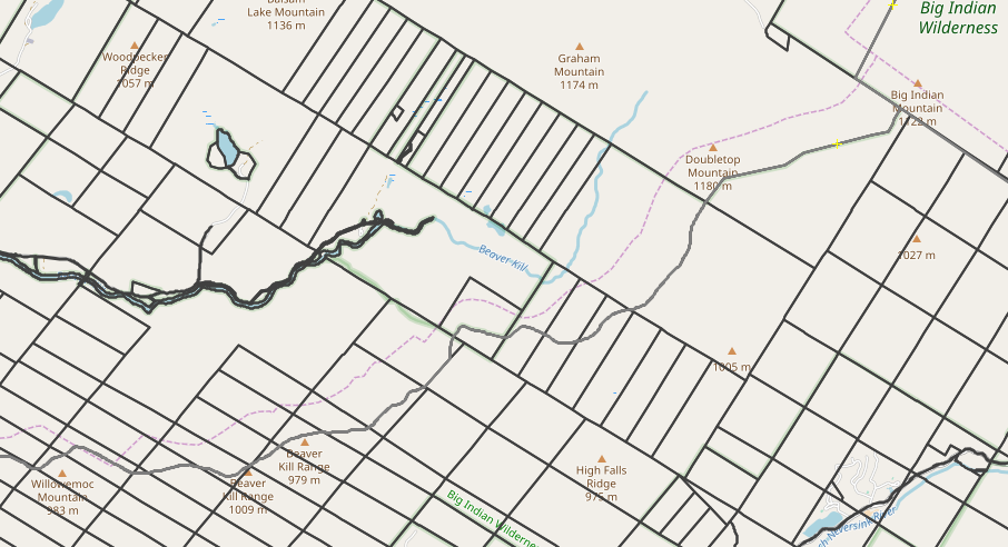
Our story begins when I noticed, while doing an import, that the Lost Clove Unit of New York City’s watershed recreation lands was badly misaligned with neighbouring parcels of state wilderness area, and that nothing seemed to join at right angles.

screenshot of the problem

In doing this sort of cadastral research in the Catskills, I’ve found that a great many parcels to this day follow the lines of the Dutch and English land grants of the 17th and 18th Centuries. This practice is so common, in fact, that the managers of New York’s Catskill Park commissioned a 1970 map showing state-owned lands (as they stood at the time; the state has acquired additional parcels in the intervening years) referenced to the land grant, great lot and small lot. (Warning: This map is imperfectly rectified, so it’s unwise to trace from it. It’s still usefui as a general guide to how things are laid out.

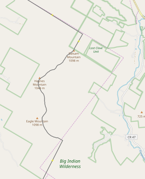
In comparing OSM against the map of the land grants, I see that the vast majority of the property lines do, in fact, follow the old land subdivisions. But what leapt to my eyes was a surprise: the line between the Towns of Hardenbergh and Shandaken on the state map is significantly different from the one in OSM. The map from the state shows the boundary following the ridge of Balsam, Haynes and Eagle Mountains. The one in OSM is a zigzag of straight lines between the ridge and the Esopus Creek, , as far as a mile off at one corner. Something’s strange here!

1970 state map and OSM overlaid

OK, that state map is pretty old, but I’m pretty sure that everything outside the wilderness areas east of the ridge is Shandaken Township. What does New York State’s official shapefile (which is actively maintained) say? Fire up OSM, and set up the map and image layers, and let’s see. Looks as if the line is still up there on the mountain tops!

Comparison: OSM vs 2019 NYS GIS boundary data

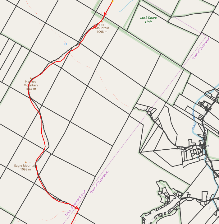
Throwing in the Ulster County tax parcel data as another layer shows that the county has roughly the same idea as the state. The two stray apart by as much as a couple of hundred feet, but that’s actually not all that bad for an indefinite boundary in deep woods and broken terrain. I’ll say that’s good enough.

Comparison: OSM vs 2019 Ulster County tax data

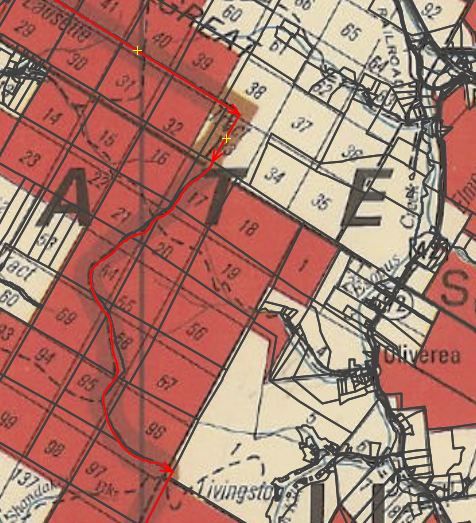
Particularly since they both align with the 1970 state map - Note that the tax parcels are also in decent agreement with the lots in the old land grants - at least good enough to identify the lot numbers.

Comparison: 1970 Catsill Park map vs 2019 Ulster County tax data

And, whoops, it looks as if there’s some misalignment farther south as well. The county and state agree perfectly, but OSM appears to be astray.

Comparison: OSM, Ulster County, NYSGIS, Denning-Hardenbergh town line

For what it’s worth, the 1970 map also has pretty fair agreement here.

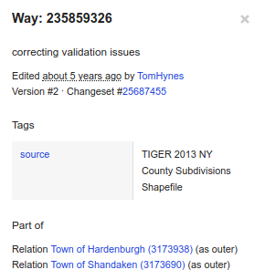
OK, before I start charging off to fix this, where did the OSM data come from? Select the way that corresponds to the Hardenbergh-Shandaken town line, and look up its metadata:

source=TIGER 2013 NY County Subdivisions Shapefile

TIGER 2013. We know that TIGER 2010 had a problem with political boundaries in New York, but 2013 got a fresh copy from USGS, so it looks as if USGS has the problem, also. Let’s take a troll through the historical topo maps and see if we can spot what’s going on.

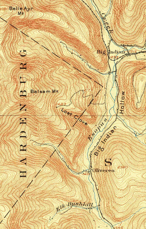
There is essentially only one 15-minute topo (the Phoenicia quadrangle) from the area, based on the 1903 survey. Sure enough, it shows the questionable boundary. For all I know, that’s where the line was in 1903! Printings of this quadrangle from as late as 1948 show the line in the same place.

Phoenicia, 15-minute quadrangle, 1903

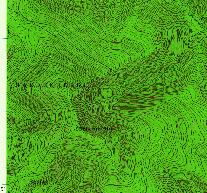
In 1945, the Army Map Service produced the first 7.5-minute quadrangle map of the affected area (Shandaken). It moves the town boundary up to the ridge, while continuing to misspell ‘Hardenbergh’.

Shandaken, Army Map Service 7.5-minute quadrangle, 1945

The 1960 USGS 7.5-minute quadrangle revises the town boundary to something close to what the state has currently, while retaining mapping for the hiking trail that follows the ridge. It also finally spells ‘Hardenbergh’ correctly.

Shandaken, USGS 7.5-minute quadrangle, 1960

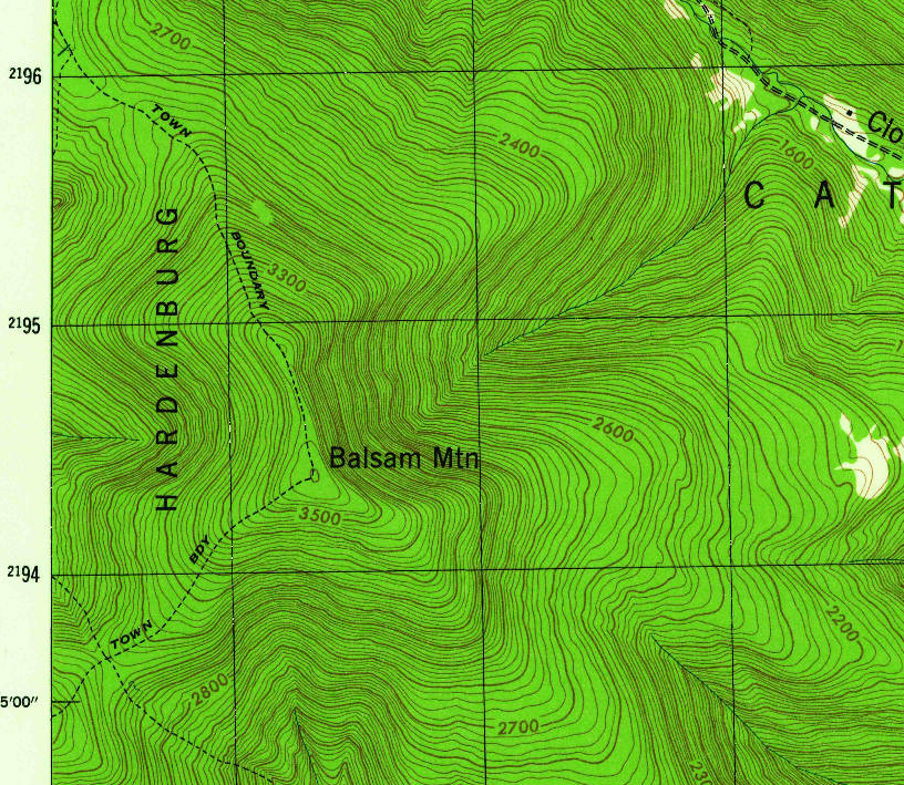
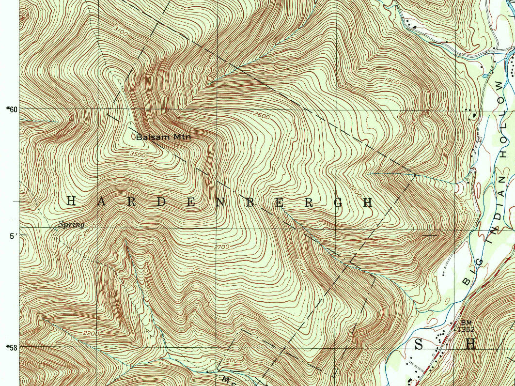
But in the 1997 edition, the geometry from 1903 is back - this time at 7.5-minute scale. ‘Hardenbergh’ is still spelt correctly, but the zigzag of straight lines matches the 1903 survey, discarding the changes from 1945 and 1960.

Shandaken, USGS 7.5-minute quadrangle, 1997

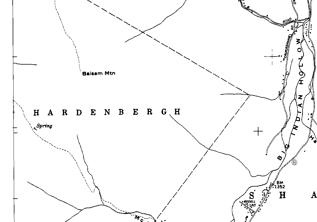
It appears that the data source for this reversion was likely the 1973 NYS Department of Transportaion 7.5 minute topo map, whose black overprint layer lacks the boundary corrections of the 1946 and 1960 maps, although it does spell ‘Hardenbergh’ correctly.

Shandaken, NYSDOT 7.5-minute quadrangle, black ink layer only, 1973

So where do we go from here? Since three separate agencies today (NYS Department of Homeland Security, NYS Department of Environmental Conservation, Ulster County) all agree on the boundary now, and since they are the ones with the greatest interest in getting it right (they collect the property tax on the land!), I’m going to go with their location of the line.

To deal with the small differences and make everything topologically consistent, I’ll use county parcel data for the town line between Big Indian Mountain and the corner north of Balsam Mountain, and conform the boundaries of the Big Indian Wilderness and the Lost Clove unit to the county data in that region for topologic consistency. Elsewhere, I’ll use state data for the town lines except for this area (conflating points at the junctions, and revise the lines that separate the Towns of Hardenbergh, Shandaken, Denning, Neversink and Wawarsing, all of which are misaligned badly to state and county cadastre.

The results will surely not be 100% correct, since surveys disagree, but will at least be topologically consistent and better than what’s there.

Sometimes, mapping is like writing Roots!

P.S.: It’s somehow appropriate that Hardenbergh should be the township with the trouble.

http://clermontstatehistoricsite.blogspot.com/2009/10/great-hardenbergh-patent.html http://clermontstatehistoricsite.blogspot.com/2009/12/hardenbergh-2-even-harder.html

give some idea about the complexity of local history. The feudal land tenure in the area even gave rise to a civil war.

Location: Town of Shandaken, Ulster County, New York, United States

(US) State Parks: Searching for common ground

Posted by ke9tv on 13 July 2019 in English. Last updated on 20 July 2019.

(US) State Parks: Searching for Common Ground

DRAFT FOR COMMENTS: Please do not treat as a formal proposal!

Introduction

For as long as I’ve been a participant on the OpenStreetMap project, the subject of what to tag a ‘State Park’ in the US has been fraught with controversy. (In some areas, there are equally controversial facilities named ‘county park’, ‘town park’ and so on with similar structure but administered by a still lower level of government.)

In this post, I try to find a common thread that can hopefully be used as a common foundation for all parties discussing the issue. Some of the specific examples given will be New York-centric. I apologize in advance for the fact. I am a native New Yorker, and I use examples with which I am familiar. I strongly prefer to map in places where I have boots on the ground - by which I usually mean literal boots on the literal ground. I have trodden the soil of all the places that I use as examples.

Proposal summary

State Parks should, as a ‘lowest common denominator’ be tagged with boundary=protected_area protect_class=21 (This combination would be the minimum necessary for rendering. Ordinarily, a state park would also have some combination such as protection_object=recreation protection_title="State Park"

Background

One issue driving much of the controversy behind State Park tagging is that none of the ‘land use’ terms really fits. Many State Parks in the US are multipurpose recreational facilities. Portions of them may fit well with leisure=park (often understood to be a human-sculpted landscape crafted for visual enjoyment), landuse=recreation_ground, leisure=nature_reserve, leisure=golf_course, leisure=camp_site, tourism=museum, and many other things. This is because a common pattern is that a State Park will usually be a multipurpose facility intended to draw residents into outdoor pursuits. A typical one include a section that is preserved in a natural state for pursuits such as hiking and birdwatching, as well as sections with sport pitches, swimming or boating facilities, picnic areas, perhaps a campground, perhaps a band shell or amphitheatre, concessions, playgrounds, perhaps a golf course, perhaps a section reserved for summer youth programs (day or residential). Museums on site are not too uncommon. Some of the larger ones host restaurants, rental cabins and inns. The developed parts of the park can be referred to as ‘front country’ facilities, in contrast with the ‘back country’, which is nearly devoid of such comforts, offering hiking trails, a wilderness-like experience - and very little else.

Some tagging purists will say that only these individual facilities ought to be mapped: that a State Park needs to be carved up into the areas that host the disparate activities and all need to be mapped separately. This approach is probably the most formally correct. Nevertheless, it has a few drawbacks. Chief among these is that a State Park does have an existence as a whole. There is an object out there in the world, which ordinarily will have signs directing travelers to it and announcing its presence, whose name is familiar to not only those in its immediate vicinity but those in the broader community that it serves. Speaking about the ‘Trailside Zoo’ or the ‘Fort Clinton Museum’ to a Downstate New Yorker is likely to get you a blank look. Adding, ‘in Bear Mountain State Park’ will then make the object suddenly recognizable. It is the park that is known by name and boundaries, not the facilities within it. Requiring that the parts be mapped instead of the whole also gives rise to an attitude that the facility must be micro-mapped in order to be mapped at all. The common mapper pattern of ‘fill in the map with broad brush strokes, then paint in the details’ does not work if there is no colour that may go on the broad brush!

Previous disputed approaches

This desire to tag the whole facility leads mappers to force-fit tagging that is at best controversial and at worst inappropriate. This has typically sorted out into several things.

  1. leisure=park This term is frequently used sensu lato by mappers to denote any government-run facility for outdoor recreation, not just for the sculptured landscape that many other mappers expect sensu stricto. This particular tag is used widely enough that one must conclude that it is ‘broadly accepted’ by a subset of the community. Nevertheless, the argument that it is a tag misuse is a compelling one, however broadly the tag has been applied. The tagging certainly feels wrong for a facility such as Bethpage State Park in New York, which is largely taken up by a golf course!

  2. leisure=nature_reserve Since State Parks often contain some ground that is left in essentially a natural state (the amount may range from a few hectares to hundreds of square kilometres), and since one aspect of a State Park is protection from development, this tagging is at least plausible for many of them. Nevertheless, it is surely not right for the ‘front country’ portions such as recreation grounds and campgrounds. ‘Nature reserve’ can be applied to a lot of things, but for most State Parks it is either being stretched to be breaking point or else woefully non-specific.

  3. boundary=national_park This tag actually appears to fit a few State-run facilities, at least if one takes a broad reading of the definition on the Wiki: ‘a relatively large area of land declared by a government […], to be set aside for human recreation and enjoyment, as well as the protection of the natural environment and/or cultural heritage of an area.’ I make the case elsewhere that there are at least a couple of State facilities for which no other tagging really fits. The two that I discuss in particular, the Adirondack and Catskill Parks in New York, arguably were the prototype for the US National Park System. They (along with Yellowstone, which became a ‘national’ park because Wyoming was not yet a state, and Yosemite, which was a State Park before being deeded to the Federal government in 1906) are arguably the prototypes of the US National Park system. They bear all the indicia of a national park with the exception of which sovereign has designated them. I happen to believe that a case could be advanced that a few of New York’s State Parks (enormous ones like Allegany or Harriman, or spectacular ones like Watkins Glen or Niagara Falls) could be marked with the boundary=national_park label, but I have not done so. Part of the reason is that it would open the floodgates to a torrent of mistagging. There is no way that a suburban recreation facility like Hempstead Lake or Nyack Beach would fit the boundary=national_park designation other than by stretching the meaning of the tag beyond the breaking point. It is certainly not universally applicable to State Parks.

  4. park:type=* in combination with one or another of the above tags has been proposed, and gained some traction, but is not in truly wide use. Its use has also faced heated controversy. The tag was an early attempt to communicate the ideas that we now have codified with ownership=* and protection_title=*. Its free-form nature, the lack of documentation in the Wiki until recently, and the invented values that it accumulated as a result, meant that it failed to offer clarity. The newer tagging schemes have largely supplanted it, and park:type=* should be viewed as close to being deprecated.

A new look at the problem

With all of these ideas essentially proving a failure in the general case, it’s necessary, I think, to step back and ask:

Is there any attribute that all State Parks have in common, that pretty much all mappers would agree on, even as other attributes might vary widely?

Is there any existing, more-or-less established, tagging that could represent that attribute?

When I look at the problem from that perspective, I realize - quite surprisingly - that there just may be an answer to those two questions that could establish at least a fundamental, widely agreed (if not widely implemented) foundation on which to build. That attribute is protection. One indicator that a State Park almost certainly has is that it is protected from development to preserve its value to the community as a recreational resource. I would therefore argue boundary=protected_area is a tag that all might be persuaded to accept. I don’t claim that it could possibly resolve the controverses over ‘what is a park,’ ‘what is a nature reserve,’ or ‘what is a national park.’ It surely cannot. But if there is even one single tag which all can accept as ‘not wrong, not a falsehood’, then there is something that mappers can use, secure that it can persist beneath the cacophony of arguments over what else to call the thing - arguments in which, I argue above, none of the proponents is entirely right.

I anticipate the counterargument, “How can you call a place that has been cleared for playing fields, had a pond excavated and dammed for swimming, and even had a hotel built on it, a ‘protected area’?” I believe that argument is founded in the idea that all ‘protected areas’ are what the Wiki page calls nature protected area (i.e., ‘protect_class=1a’ through ‘protect_class=7’, plus the special classes 97, 98 and 99). The typical State Park is not one of these. Farther down the page, however, we see another major classification: social protected area - and within that, protect_class=21 ‘Community life’, with recreation being stated as one of the protection objects that may be recognized within the class. The typical State Park is indeed protected for the sake of community life, and reserved for public recreation. “Parks and recreation”, indeed, is a typical title for the government department that administers them. They may not have their natural landscape protected in any way - indeed, they may be an entirely artificial landscape. (Indeed, (Riverbank State Park)[https://www.openstreetmap.org/way/118524694] is built entirely on the roof of Manhattan’s massive sewage treatment plant.) But the areas are protected in the sense that there will be intense political repercussions if anyone were to propose strip mining them, building condos, opening a shopping mall, or condemning them for a freeway. They are indeed ‘protected for community life’, with the object of ‘recreation’.

Proposed tagging

I would therefore propose that a ‘lowest common denominator’ acceptable tagging for State Parks would be:

boundary=protected_area protect_class=21

This pair would be the minimum to determine the rendering. Usual additions would include:

protection_object=recreation protection_title=State Park operator=State of XXX (or Commonwealth of XXX for Kentucky, Massachusetts, Pennsylvania, and Virginia) site_ownership=state protected=perpetual

together with whatever other common tagging (name=*, wikipedia:en=*, website=*, opening_hours=*, etc.) is deemed appropriate.

Each of these tags represents a fact that can be established objectively - in fact, the first group is practically implied by the name, ‘State Park’ (ignoring anomalies such as Donald J. Trump State Park which is best described as landuse=brownfield).

Current state of the tag usage

The protect_class=21 tag is already in use. As of this writing, taginfo shows 571 features with the tag.

This statement, is however, somewhat disingenuous, because virtually all of the features with the tag have it because I put it there! I did so because I was editing the features for other reasons, and decided to follow my reading of the Wiki’s boundary=protected_area guidelines. The only public discussion that this protect_class has received in my edits is that when I proposed reimporting the NYS DEC Lands shapefile, I proposed that protection class for State Multiple Use Area, State Fishing Access Area, the corridors protecting recreational trails, and the easements for access to landlocked parcels open to public recreation. There were few if any comments on this particular aspect of the proposal. I also at one point conducted an audit of New York’s State Parks and State Historic Sites, establishing some uniform tagging (for instance, directing the website=* on all of them to the appropriate page on https://parks.ny.gov/. I added the protected_area tagging to these at the same time. (I also added protect_class=22 for State Historic Sites.) Using taginfo to answer that question is for me, therefore, simply listening to an echo.

With that said, adopting the tag will give rise to extremely little conflict. Using Overpass Turbo, for instance, I see the tag on only three objects in Europe: a church in Boguslav, Ukraina, and tiny parcels of open space in Athens and the Balearic Islands. There are also a handful of uses in North America outside New York that all appear to be compatible with the proposed scheme. In short, this portion of the tag space appears, if you will pardon the pun, to be a green field for future development.

Rendering

protect_class=21 is not one of the classes that is currently rendered in OSM-Carto, (which handles only classes 1a through 6, if memory serves). I am optimistic that if this proposal gains traction, eventually the rendering will follow. What I think might work for is an appearance similar to what is used for a nature reserve, except that instead of the deep green highlight on the interior side of the boundary line, a pale green highlight suggestive of the infill of leisure=park (#c8facc) might be appropriate. It is important to note that this suggestion comes from a colour-blind mapper, so someone with an artist’s eye had better review it! I am advised by the OSM-Carto maintainers that if this tagging becomes popular, the change is a relatively simple one to make.

As a more problematic side issue, OSM-Carto does not at present render boundary=protected_area, boundary=national_park or boundary=aboriginal_lands when they appear on simple closed ways. This is a known issue. Because there is already a pull request with the necessary changes, I am confident that it will be resolved eventually. Nevertheless, it will take longer to fix than simply adding the rendering of class-21 protected areas, because it requires a rebuild of the database that drives the tile server. Since this is an operation that requires months of planning (and significant server downtime), it is contemplated only once every few years - and no such rebuild is scheduled at present. In the meantime, a workaround would be either to make sure that the boundary=protected_area tag appears only on multipolygons (creating a multipolygon comprising only a single polygon if necessary) or forcing the correct rendering by including area=yes.

In short, the rendering issue is still a bit open. Still, just as we eventually got at least some rendering for boundary=protected_area, I am confident that protect_class=21 can follow.

Interim tagging

Any discussion of interim tagging is likely to be met with the accusation that it’s ‘tagging for the renderer’. I do, however, observe that a great many State Parks are already mapped, and the mappers who added them would surely push back if told to map the objects in a way that will disappear from the map until the renderer catches up.

While the existing ways of mapping are all somewhat inaccurate, they’re not ‘tagging for the renderer’ in the sense of ‘painting ink without regard for semantics.’ In most cases, the mapper has made the uncomfortable decision of whether to call the feature a ‘park’, a ‘recreation ground’, a ‘nature reserve’ or something else. Until class-21 protected areas are rendered, it introduces no conflict to continue this tagging while adding boundary=protected_area protect_class=21 to the feature.

Unfortunately for the State Parks that have been tagged boundary=national_park, a necessary intermediate step will be that these (aside from ‘corner cases’ like the ones in the earlier diary entry) will have to give up the boundary=national_park tag, in order not to conflict with the incoming boundary=protected_area tag. They, too, can acquire one of the inaccurate tags listed above, in order that they will not disappear from the map as a result of the tag conflict.

The tagging of the Adirondack and Catskill Parks as boundary=national_park has been fraught with controversy. I’m more or less responsible for the tagging decision, and I’ve decided to make a diary entry explaining it, so that I don’t have to keep repeating the explanation.

These two entities are not ‘State Parks’ - unlike other parks such as Allegany State Park or Harriman State Park. In fact, they are unique entities in New York, and quite possibly the US and even the world.

Unlike most parks, which are created by statute, or even by executive proclamation, the Adirondack and Catskill Parks were created by a constitutional convention in New York, and are explicitly enshrined in article XIV of the state constitution, which begins:

The lands of the state, now owned or hereafter acquired, constituting the Forest Preserve as now fixed by law, shall be forever kept as wild forest lands. They shall not be leased, sold or exchanged, or be taken by any corporation, public or private, nor shall the timber thereon be sold, removed or destroyed.

This is the strongest protection enjoyed by any park or nature reserve of which I am aware. While all the others that I know about could be destroyed by a legislature’s passing a bill, any significant change to the Adirondack and Catskill Parks requires a constitutional amendment. There have been several such over the years, but none has come close to repeal. The most significant ones were the authorizations to construct the Olympic sports complex at Lake Placid, to build Interstate 87 through the Adirondacks, and to permit New York City to construct reservoirs and draw its water supply from the Catskills.

The parks are represented by an arbitrary line on the map (called the Blue Line because of its traditional rendering on official state maps), in which any land that the state acquires for conservation purposes becomes ‘Forever Wild.’ The private land inside those parcels is extremely tightly regulated to control development. While the parks contain highways, villages, farms, working forests and mines, the inholdings up north are beholden to what has been called the world’s toughest zoning board: the Adirondack Park Agency.

The boundary of the park is, to the locals, the most important administrative boundary in the region. For instance, real estate listings in the area will almost always state whether a property lies within or outside the Adirondack Park - that fact is far more significant to the landowner than which county or township the land falls in.

The way the parks are organized is reminiscent of National Parks in Europe. As an example, the Cairngorms National Park in Scotland contains villages and farms, aerodromes, aquaculture facilities, airfields, ski resorts. It is a mixed-use area, although the primary and overarching land use is conservation.

I’m comfortable as well with the word, ‘national’, because in the US the States are sovereign entities in their own right. Virtually all issues of land ownership and use are the prerogative of the States, and in most cases the Federal government may not intervene. New York’s two great parks therefore are designated by a sovereign entity and enjoy stronger legal protection than any of the US National Parks.

The level of significance is also consistent with the ‘national park’ designation. The Adirondack Park encompasses a greater land area than Yellowstone, Everglades, Grand Teton, Glacier and Cascade combined, and the portion that is owned by the state and Forever Wild is bigger than any two. In fact, there was a proposal floated in the 1960’s to transfer the Adirondack Park to the National Park Service, creating an Adirondack National Park. The proposal was spectacularly unpopular, and failed, but provoked a significant reorganization of the state’s executive agencies, including creation of the independent Adirondack Park Agency.

Moreover, just as in Scotland with the Cairngorms, other designations would give rise to considerable confusion. When there are parks - actual parks, with a single land use - within another park, rendering becomes confusing (particularly if the alternative is leisure=park, shown only by a coloured infill) and topologic queries are equally confusing. This sort of issue affects the Adirondacks (with, for instance, the Lake George Battlefield Park within the Adirondack Park) and the Cairngorms (the Glenmore Forest Park within the Cairngorms National Park) alike.

There truly is no good tagging available, in the sense that the choice of tag will avoid controversy. The tagging chosen is far from the least controversial that could be chosen, but comes closest to expressing the intent of the People when the constitution that created the parks was ratified.

This is not wholesale tagging of State Parks as boundary=national_park, but rather a considered choice for two features that are truly unparalleled in the nation. When I looked farther afield than the US, the only comparable features that I found were national parks in other countries.

The only coherent objection that I’ve heard thus far is that they don’t have ‘National Park’ in their names and that they they aren’t administered by the National Park Service. That itself is tied up in the history of our National Parks: New York had the idea first, and Teddy Roosevelt took it with him to Washington. (To this day, New York has very few NPS facilities, because we got along quite well indeed without them.) These two parks serve the same function and have most of the same indicia (other than trademark) of our large National Parks. They simply happen to have existed before the Federal government was in that business. (The only National Park that’s older is Yellowstone - and it couldn’t have been a state facility when it was established, because it predates Wyoming’s statehood.)

Besides, I’m willing to tolerate a few anomalous tags for an administrative region that’s the size of a small country. (The Adirondack Park is about equal in land area to the State of Massachusetts. It’s considerably bigger than Slovenia or Luxembourg, a little smaller than Belgium.)

Camp Smith, Peekskill, New York

Posted by ke9tv on 14 December 2017 in English.

I’ve been trying to get public land boundaries in New York State tidied to where trail maps will show reasonable results for the parks and forests.

One problem that was recently called to my attention was Camp Smith in Peekskill, New York. Researching this area revealed rather a complex history, and I thought that I had better write this diary entry to explain what I did, since it doesn’t quite agree with any of the ‘authoritative’ data sources.

Camp Smith, purchased by New York State between 1923 and 1940, is a National Guard post, and as such, is State land rather than Federal. The Hudson Highlands State Park that borders it is also, of course, State land, and in fact, portions along the north of Camp Smith had been carved out of it historically to create a corridor for the Appalachian Trail.

On that state land, a trail from the Bear Mountain Bridge to the summit of Anthony’s Nose has existed for a very long time. I know that I visited Anthony’s Nose as a Boy Scout in the late 1960’s. Since at least 1993, there has been a trail open to the public that takes a strenuous course from there southeast along the cliffs, with many fine view overlooking the river. Everyone understood it at the time to be a way along which public access was granted, that traversed the grounds of Camp Smith.

In 2001, the political climate of the time forced Camp Smith to post its borders as being closed to the public. The recreational opportunities were restored in 2002 (at the same time as the historic site was created for the old Bear Mountain toll house) by changing the land management. The Hudson Highlands State Park was expanded to 50 feet northeast of the trail center line, and all of the land between there and the rail grade on the riverbank came under the management of New York State Office of Parks, Recreation and Historic Preservation. The flyer that is given out at the trailhead details this situation, and warns hikers that they may encounter the occasional patrol of Guardsmen, to whom they should give way.

Since this move was, in effect, a transfer of land from New York State to itself, there was very little formal record of it, and the official maps all still show the old boundaries. In many cases, owing to database incompatibilities among the state agencies, even the official maps are full of gaps and overlaps at the border between the two reservations.

It seemed important to me to indicate that the trail on the cliff top is open to the public, not subject to the restrictions of the military post. I therefore adjusted the boundaries of the military reservation as follows, and conflated them with the boundaries of the state park:

  1. A line fifty feet from the trail was created using the ‘buffer’ function of GDAL, and became the boundary wherever it penetrated into former Camp Smith lands.

  2. The (otherwise questionable) import of Camp Smith from a Federal database was retained. Where it was adjacent to roads, it aligned well to the road network and to aerial images. In the woods, the borders are indefinite in any case. The Westchester County portion of Hudson Highlands had originally been reconstructed from county tax data, which were recognized to have problems with alignment, partly due to mixed datums.

  3. Anywhere that Camp Smith and Hudson Highlands were coterminous, their joint border was replaced with a shared way.

This is pretty close, I think, to the situation that exists in the field. Indefinite borders are always a bit of a headache, but this change should at least clarify that the hiking trail is open to the public.

New York Long Path

Posted by ke9tv on 2 May 2016 in English.

I noticed that there were New York Long Path blazes when I went out a week ago (2016-04-24) to map the Wolf Creek Falls Preserve. (Actually, I knew in advance that they were there…) That made me remember that mapping the northern part of the Long Path ought to be a project. There are essentially no really good trail maps available of this trail from Huntersfield Mountain in the northern Catskills through the Schoharie Valley to its terminus (Thacher Park or Northville, according to whether you want to take it all the way to the Adirondacks). OSM has the opportunity to fix that.

I’ve started adding roadwalk and overlaid trails to the route relation, and posting notes for the missing sections. If nobody else does it, I’ll get out and GPS the missing sections at some point, but no real promise when that will happen.