
Northwick Park Hospital buildings
Posted by Harry Wood on 19 May 2021 in English. Last updated on 23 May 2021.Last night I sat and armchair-mapped a load of hospital buildings for Northwick Park Hospital here in North West London
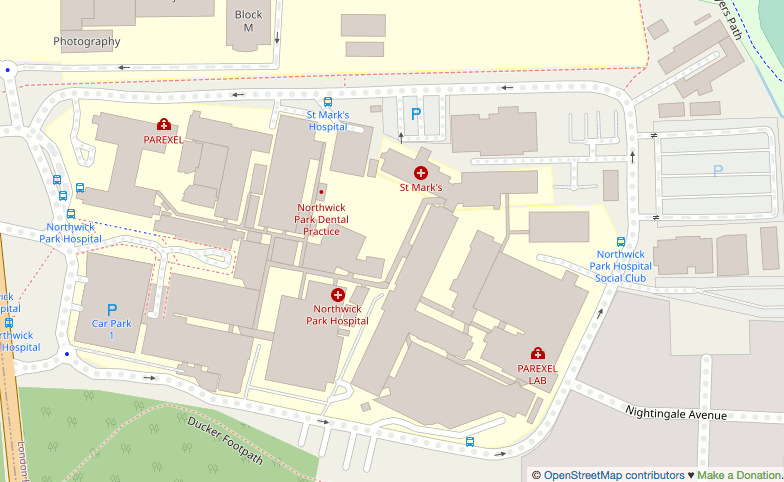
I tend to follow a rule of no armchair mapping in the UK these days, but I have a few extenuating considerations where I allow myself to break that rule. This is a big hospital. It’s the kind of thing we should certainly have mapped properly across London and the whole UK. I’ve armchair-mapped quite a few hospital buildings like this in Africa after all! I wonder how many other UK hospitals are missing building detail.
Actually the omission seemed wierd to me, as if maybe the buildings had been mapped but recently deleted. I thought it looked as though somebody had swept in and hit delete but missed just one or two little buildings (that little dentist), but how to prove it? I spent some time trying to figure out if I could find deleted nodes in a very constrained bbox e.g. using Overpass date features, but I gave up. Finding deleted data is difficult.
Denying the chance for somebody living locally to take care of their map, is the micro-harm that we potentially do when armchair mapping. I started by putting a simple note, and waiting 3 months, partly in the hope that somebody living more locally might see that.
The missing buildings were actually pointed out to me by SK53 during our London virtual meet-up. I suppose this is the main extenuating consideration actually. I sort of feel like if people are having conversations about bad data, then somebody really ought to go ahead an fix that bad data. So yes… It’s fixed! Although actually I’ll drop a couple more notes where I remember aspects of the imagery being a little unclear. “Survey needed”. And of course surveying could add much more detail. Footway connectivity outside and maybe even inside. Names of more of the buildings. etc. So if you do live local… get stuck in! I wonder what’s the best example of hospital detail in the UK. Cambridge and Edinburgh can be relied upon to provide pretty good examples!
Speaking of that London virtual meet-up… we should do another one! Or maybe even a real pub meet-up again some time soon! I’m still pondering other virtual event formats too. That last one was fun, and was basically a great chance to catch up between friends. For the first few hours we didn’t even talk abut OpenStreetMap much. Later on the zoom call I thought about how to direct the conversation back to OSMLondon, and so I shared my screen and started panning around the London map at random. As expected this prompted a few conversations including SK53 pointing out these missing hospital buildings. I’d like to do something like that again. Or what’s the best map/data view to prompt interesting conversations I wonder?
Another thing: I’m still “between jobs” at the moment which means, while I’m not exactly at a loose end (With job hunting and kids I’m feeling surprisingly busy still), it occurs to me I could run some kind of virtual OSM event during working hours. Crazy idea? It would suite me a lot better actually, but would rule out most of the normal crowd I’m sure. Could be good for attracting different kinds of people. Maybe we can do both. Let me know what you think.
Update! OSMLondon zoom call scheduled for 8pm on Sunday 23rd
Discussion
Comment from Rovastar on 23 May 2021 at 10:00
Well done for mapping that. I still fail to understand we people refuse to do armchair mapping. Like it is a dirty unclean part of OSM and shouldn’t be done as it does massive harm. I still think it is massively a force for good. Relying on notes for others to fix instead of fixing things yourself seems a fool errand. Sometimes with the posting notes for someone else to fix (when I could fix it myself) people think there are millions of mappers that are so bored/unobservant that they spend all day just looking for notes for something to do. Obviously, this is not the cause. The amount of regular mappers in the whole of the UK (or the world) is really vanishingly small and we are one of the countries with the most regular mappers.
Let’s take that area as an example. Your note sat there is 3 months no one did anything. The area around it is not well mapped so I’m guessing there are no passionate mappers nearby anyway. But if you look at the other notes around there, they are much older.
Just to the top of your screenshot in the Uni area there are a load of notes 4 years old (on buildings that are 5 years old). So no-one really is looking at these notes which could have been a clue. One of them is about a “courtyard Building” that seems an error and didn’t appear on ariel imagery then and looks an actual courtyard.
Now this is still there, and aerial imagery has been updated, and it is still a courtyard and not a building. (OS doesn’t show a building either)
What are we to do about it? Post another note and the mapping fairies will physically visit. Or do we say with confidence that we can delete the building? I would happily delete it but then I feel that the anti ariel mapping gang will be up in arms about that as I haven’t visited it myself. And think that if you don’t visit it yourself the imagery is lying. Bring out the tin foil hats. Obviously mapping in person on the ground is better and more useful notes of the type “I’ve done my bit, it loads better than it was, if anyone is around here it could do with a survey” are great as well.
That rant over, it does seem like 8 years ago most of that hospital was mapped unsure when everything was deleted. I am a little surprised at the details missing from the hospital I thought (but maybe be mistaken) a year or three ago there was a quarterly challenge about hospitals and medical stuff so thought more would have been caught.
I am often fairly free in the day if you have a virtual OSM meet. (I’m not sure there is a reason for specific localities for virtual meetings. A OSM England or OSM UK I imagine would be fine or even more desirable). That said, I would have joined the OSM London virtual meet but I had no idea it was on. Mailing lists for the win!
Comment from Harry Wood on 23 May 2021 at 13:28
Yeah I wasn’t really expecting the note to have any effect, but y’know, nice to give people the chance. The only vaguely likely scenario would be if an active mapper was watching for new notes nearby (which isn’t something I do myself so… not very likely). It would be really good if notes could somehow be a more compelling channel for new people to get interested in contributing. Entice new people to contribute by showing them fun notes to fix. Theoretically can happen, but I don’t think it ever really does happen that way at the moment.
It did occur to me maybe some folks in that Westmister Uni Harrow campus (geography or computing department?) might get interested in plugging the gap if we emailed them about it? We still could do that, but you see now I’ve removed that nice juicy bit of building mapping! So there’s the theory that my time would have been spent sending emails like that; Trying to sew a seed, but… Still a long shot. For the sake of a usable map it’s worth getting some things fixed reasonably quickly.
Anyway. Important update: Zoom call TONIGHT if you fancy joining us!
Comment from Rovastar on 23 May 2021 at 17:22
Oh tonight. I am busy for the start of it but hopefuly tune in a bit later.
Comment from tyr_asd on 25 May 2021 at 18:23
It’s actually not too hard to do using the ohsome API if you have some basic (Q)GIS skills:
elementsFullHistory/geometryohsome API query; same for the time range and filter (I usedgeometry:polygon and building=*here)I cannot find any hints of deleted hospital buildings in that area. How did you come to your conclusion @Rovastar?
Comment from Adrian 2 on 5 June 2021 at 20:26
I managed to get the ‘attic’ (historical) data for Northwick Park Hospital at annual intervals from 2012 to 2021. There are hardly any buildings except in 2021. So any buildings that may have been there, were there for less than a year.
It wasn’t easy to get the data. I spent some time tweaking the Overpass query before I found a query that didn’t time out. It didn’t seem reasonable to try to fix the problem by extending the time-out from the default of three minutes.
I tried the method described by tyr_asd. It was easier to get the data, but I had trouble with QGIS. It just showed a blank, white map, although the objects were there. I had to quit and relaunch QGIS to get it to work properly. The use of the temporal slider was very effective. It showed there were hardly any buildings from 2012 (the start time I chose) until late 2020.