Just finished aligning the northern half of Jabor-Jerangau highway (about 50km) to newly available Bing imagery. Since the highway was originally created based on a gps track (I think), there was quite an offset between the gps track and Bing.
Also in some areas, it seemed that hiways on Mapbox imagery lay much closer to accumulated gps track than Bing, but that can possibly be attributed to the difference between coarse level 17 zoom to Bings level 18/19 color imagery. Bing is about 20-30 meters away from gps tracks.
I think I’ll wait for more gps tracks before I offset the imagery. For now, I’ll focus on making pretty highways…
Thank you Bing.. need moarrr…
Discussion
Comment from flohoff on 30 December 2015 at 09:50
An offset between Sat/Aerial Imagery and GPS Tracks is in 99% caused by broken imagery georeferencing. So you better stay with GPS tracks and fix the imagery offset.
Comment from Hjart on 30 December 2015 at 10:40
Do not take for granted that Bing imagery is correctly aligned. gps-traces may be not be accurate either, but since I see several that seem fairly good quality along that highway, I would trust them over Bing.
Comment from Rovastar on 30 December 2015 at 12:07
Often Bing is much better than some dodgy GPS track. Carry on aligning. So people here do not modern technology to contribute to openstreetmap.
Comment from BushmanK on 30 December 2015 at 17:46
Gentlemen, it’s better to leave aside all assumptions and personal beliefs. Take a look at this example (open it in new window):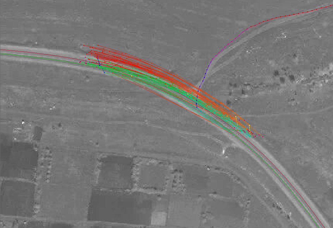 Two single tracks, currently perfectly aligned with road, are from precision GPS measurement (raw data processed with RTKLib). Image was shifted several meters away from the true position before it was aligned to these two tracks.
The whole bunch of red and green lines near the intersection are tracks, collected by different people using their dash receivers, handheld navigators and smartphones. All of them are systematically shifted away from the road because of Kalman algorithm filtering, implemented in every conventional GPS receiver to eliminate sudden jumps of track.
Two single tracks, currently perfectly aligned with road, are from precision GPS measurement (raw data processed with RTKLib). Image was shifted several meters away from the true position before it was aligned to these two tracks.
The whole bunch of red and green lines near the intersection are tracks, collected by different people using their dash receivers, handheld navigators and smartphones. All of them are systematically shifted away from the road because of Kalman algorithm filtering, implemented in every conventional GPS receiver to eliminate sudden jumps of track.
Conclusion: both Bing imagery and GPS tracks can have systematic (constant) shift. Only those GPS tracks, collected by precision equipment, or at least - using handheld receiver with good antenna (not a smartphone), collected by walking (not driving) are more or less good reference data. Single track with unknown origin presumably has the same or even worse quality compared to Bing imagery.
Comment from Hjart on 31 December 2015 at 10:07
I just had a look at the area again with the Strava cycling heatmap layer active (in JOSM) and see a lot of both major and minor roads covered. You may want to have a look at it, since these are generally quite reliable.
Also in my experience gps-traces collected while cycling are much better than those collected while driving cars or walking (since when walking you will often not keep your phone or gps-receiver steady).
Comment from BushmanK on 31 December 2015 at 18:29
@Hjart, Much better compared with what? Comparison of several tracks having unknown precision is useless from the point of metrology. Indeed, some obviously bad features like sudden jumps in one track and lack of them in another can make people thinking that smoother track is better, but technically, smoothness means nothing, as you can clearly see on illustration above - all tracks with significant constant shift look smooth.
But thank you anyway for mentioning Strava tracks.
Comment from Warin61 on 1 January 2016 at 07:21
From a metrology point of view;
Consumer GPS devices typically have uncertainties (with a 1 sigma level of confidence) of 10 meters.
Smart phones typically have more due to the antenna problem.
An averaging of many GPS tracks taken at significantly different times would decrease the uncertainty. Source of the reduced uncertainties are ‘noise’ from the positional uncertainty of the satellites, propagation time noise. I have multiple tracks (>30) of a bicycle ride I regularly do .. that is interesting to compare them to the satellite view. I think Tracks 4 Africa and Australia use the sampled points and combine those less than 2 sigma from the mean track derived from of all the points, and then use the remaining ones to obtain an average track. This removes the statistical outliers to give the result with the least uncertainty.
I have observed a one time offset in my personal consumer GPS of about 10 meters. That was resolved by a reboot of the device. In general the reported ‘error’ is 10 meters, but the observed accuracy is much better, possibly because my observations take place when stopped.
Satellite imagery suffers from many sources of ‘error’. One of these is parallax. Combine that with height variation over the image and the errors can be large. Having said that .. the satellite image is good at presenting a view of what is there, possibly distorted and offset. But it gives a reasonable idea. Where there are no GPS tracks it is a lot better than nothing. A simple offset correction on one image tile .. may work if the terrain is flat and level, any bumps, slops and you will probably needs multiple corrections across the tile.
Comment from BushmanK on 1 January 2016 at 19:16
@Warin61,
Only static measurements, taken in open field with open sky, have true natural distribution of position around the true point. Factors such as movement with constant speed, permanent obstacles (buildings, walls) will always lead to constant error in addition to stochastic distribution.
Talking about real accuracy and precision of own tracks makes sense only in case if you have precision reference data (fine scale map, for example) to compare. Otherwise, you can only talk about estimated error (derived from DOP, which is also an estimated value).